When waters collide

Just over a week ago I posted about the ‘tidal limits’ of Milton Drain, noting that at a very high tide, the drain is pretty much full to the brim.

Today, I braved weather that ranged between miserable and awful in order to see how the drain held up when it had more than just a high tide to contend with. With the remnants of Cyclone Oswald looming over South East Queensland, Seqwater began releasing water from Wivenhoe Dam on Friday evening, and according to the Seqwater website, the releases are expected to continue for several days. So we have the tides coming in from downstream, the dam releases coming from upstream, and the stormwater from the Western Creek catchment racing through the drains towards the river. What happens when the waters collide?
Continue reading

Once upon a time in the west

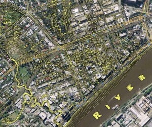
The Milton area, as depicted on a map from 1859 as depicted on a map from 1859 (Queensland State Archives, Item ID620656), overlaid on Google Maps.

The Milton area, as depicted on a map from 1859 as depicted on a map from 1859 (Queensland State Archives, Item ID620656), overlaid on Google Maps.

I’ve finally finished a new page about the early estates of Milton.

This page focuses on the early land divisions in the Milton area, and the houses and farms built on them by the early landowners. It also goes back a bit further, touching on Brisbane’s beginnings as a penal settlement, and further still, revisiting John Oxley’s discovery of fresh water at Western Creek in 1824.

I’ve tried to bring the story to life with some historical photos of the Milton area from the State Library’s collection, as well as a wonderful account of the view from the River Road written by a contributor to the Moreton Bay Courier in 1859. I’ve also had some more fun with maps, combining features from a map from 1859 with modern-day aerial photos to show the early land holdings.

I intend to follow this page up with one looking at the subdivision of these early holdings into residential estates. To that end, I’ve already spent longer than I ever imagined possible reading 150-year-old real estate columns. The results, I hope, will appear in the not-too-distant future; but as usual, I would not recommend holding your breath!

Panorama from Dunmore Terrace, 1910. (State Library of Queensland, Negatives 183958, 183967 and 183958 and 183967)

Panorama from Dunmore Terrace, 1910. Chasely Street is on the right, running between the block where Chasely Apartments now stand, and the Moorlands Estate (now the Wesley Hospital) (State Library of Queensland, Negatives 183967, 183958 and 183970)

The swamp runneth over

Since starting this project, one thing I’ve been constantly looking out for is old maps. Unless there are some unpublished photos1 or drawings floating around (and I sincerely hope that there are), maps are the only visual record we have of the old Western Creek.

Looking at maps of Brisbane from the late 1800s and early 1900s, you can see the residential lots dissolve into singular paddocks, and the road networks dwindle to just a few major arteries. In the spaces that are left, you can often find details of the underlying landscape. The oldest maps sometimes depict slopes and ridges, some of which have since been reshaped or cut down. And in between the hills you will typically see an abundance of water features — not only rivers and creeks, but also swamps and ponds — that have long since been built over.

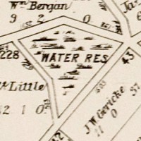
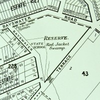
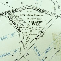
In the essay about the history of Gregory Park, I showed how the transition from Red Jacket Swamp to Gregory Park was depicted on maps from 1906, 1896 and 1884:

Queensland Surveyor General's Office (1884), Moreton 20 chains to an inch. Sheet 1B. National Library of Australia: http://trove.nla.gov.au/work/11526397

Present-day Gregory Park depicted in 1884.

Present-day Gregory Park as depicted on McKeller's map of Brisbane, 1895. (Brisbane City Council Archives)

Present-day Gregory Park depicted in 1895

Gregory Park depicted on a map published by the Queensland Department of Public Lands. The base map is dated 1906, but additional roads appear to have been added at a later date. (Brisbane City Council Archives)

Gregory Park depicted in 1906.


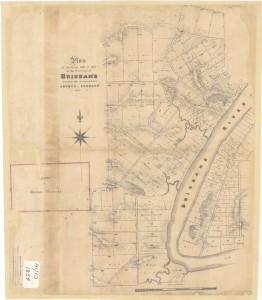
Plan of Portions 203 to 257 in the Environs of Brisbane, Parish of Enoggera, County of Stanley, New South Wales', 1859. (Queensland State Archives Item ID620656)

Plan of Portions 203 to 257 in the Environs of Brisbane, 1859. (Queensland State Archives Item ID620656)

Continue reading

Notes:

  1. In the State Library’s catalogue, there is a photos of the old Dunmore Bridge (where Coronation Drive crossed the mouth of the creek) and one of a sad looking ditch somewhere in the vicinity of Beck Street. These are the only photos I know of that show Western Creek. If you know of others, please get in touch with me!