The history of the Coronation Drive Office Park

This post is all about the part of Milton bounded by the railway, Cribb Street, Coronation Drive and Boomerang Street. If you live in Brisbane, it’s a place that you have probably passed many times without really noticing. From Coronation Drive it presents as a row of office buildings and some Jacarandas; from the train, as a car park and some Moreton Bay figs. From within, the site feels like a secluded, shady village. Interspersed with the eight office buildings and fig trees are a tennis court, a childcare centre, a multi-level carpark, an open carpark, cafes, and various shops including a Flight Centre and a real estate office. This site is known (to those who know it as anything at all) as the Coronation Drive Office Park.

The Coronation Drive Office Park is bounded by Cribb Street, the railway line, Boomerang Street and Coronation Drive.

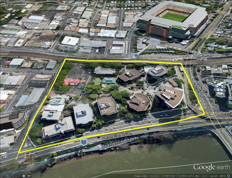
The Coronation Drive Office Park covers 4.5 hectares and is bounded by Cribb Street, the railway line, Boomerang Street and Coronation Drive.

AMP Capital, which manages of the majority of the site,1 are considering the next stage of its development. Before commencing this development, AMP Capital wanted to learn more about the site’s past. They asked me if I would like to do some research, and I jumped at the opportunity. After several weeks plumbing the depths of Trove, the Brisbane City Archives and various other sources, I produced a report documenting the history of the Coronation Drive Office Park.

You can download the report here (it’s about 13MB — apologies for the big download), but for a shorter, more web-friendly version of the story, read on below. Continue reading

Notes:

  1. Except for half a hectare at the corner of Coronation Drive and Cribb Street, the site is owned by AMP and Sunsuper.

Dipping into the history of Norman Creek

It’s always good to learn that you are not alone in pursuing a particular passion. It’s a welcoming sign that you might not be crazy after all, or that if you are, you are at least in good company. The history of Brisbane’s creeks (extinct or otherwise) is not a topic that has received a lot of attention. This is, I’ll admit, partly why the topic appealed to me. But at the same time, I liked to believe that I wasn’t the only one spending so much time thinking about it.

This is why I was delighted to meet Trish FitzSimons and learn about her research into Norman Creek. Trish is a documentary film maker and social historian who has made two beautiful short films exploring Norman Creek and its place in the lives of people who have lived, and worked and played on its waters, its shores and its floodplain.

Unlike Western Creek, Norman Creek is not just a faded memory. It is still very much alive and flowing — at least in parts. Its mangrove-flanked lower reaches meander through the suburbs of East Brisbane, Norman Park and Coorparoo, but its catchment area extends all the way up to the slopes of Mount Gravatt.

The catchment area of Norman Creek.

The catchment area of Norman Creek. (Catchment boundary obtained from this map created by the Norman Creek Catchment Coordinating Committee.)

This is a creek that has seen its fair share of use, abuse, transformation and rejuvenation over the years. And yet its story, so rich in both social and natural history, is probably all but unknown to the many people who walk past or drive over it every day. Trish’s two films — Time and Tide: The Life of Norman Creek and Time and Tide: The Boat Builders of Norman Creek — reveal how the creek has supported industry, provided livelihoods, even inspired poetry. The films also highlight how the creek has in turn been shaped and transformed over the years by a community grappling with the legacy of floodplain development.

You can watch Trish’s films via the links on this page of the website of the Norman Creek Catchment Coordinating Committee. The films were made using support from the Lord Mayor’s ‘Helen Taylor bequest for Local History’, and they are an important contribution to the story of our city. Yet at the same time, they are but tantalising sips from a much deeper pool of history that is waiting to be explored. Trish tells me that she has many more stories to tell about Norman Creek, and that they might even feature in a public exhibition somewhere down the line. I can’t wait to dive in!

Once upon a time in the west

The Milton area, as depicted on a map from 1859 as depicted on a map from 1859 (Queensland State Archives, Item ID620656), overlaid on Google Maps.

The Milton area, as depicted on a map from 1859 as depicted on a map from 1859 (Queensland State Archives, Item ID620656), overlaid on Google Maps.

I’ve finally finished a new page about the early estates of Milton.

This page focuses on the early land divisions in the Milton area, and the houses and farms built on them by the early landowners. It also goes back a bit further, touching on Brisbane’s beginnings as a penal settlement, and further still, revisiting John Oxley’s discovery of fresh water at Western Creek in 1824.

I’ve tried to bring the story to life with some historical photos of the Milton area from the State Library’s collection, as well as a wonderful account of the view from the River Road written by a contributor to the Moreton Bay Courier in 1859. I’ve also had some more fun with maps, combining features from a map from 1859 with modern-day aerial photos to show the early land holdings.

I intend to follow this page up with one looking at the subdivision of these early holdings into residential estates. To that end, I’ve already spent longer than I ever imagined possible reading 150-year-old real estate columns. The results, I hope, will appear in the not-too-distant future; but as usual, I would not recommend holding your breath!

Panorama from Dunmore Terrace, 1910. (State Library of Queensland, Negatives 183958, 183967 and 183958 and 183967)

Panorama from Dunmore Terrace, 1910. Chasely Street is on the right, running between the block where Chasely Apartments now stand, and the Moorlands Estate (now the Wesley Hospital) (State Library of Queensland, Negatives 183967, 183958 and 183970)

New page – John Olxey and the chain of ponds

Happy Easter!

Though I’m feeling slightly guilty for being inside when the weather is so stunning, I’m glad to announce that I’ve posted a new page to the site. John Oxley and the chain of ponds explores Oxley’s trip up the Brisbane River in September 1824, during which he landed near Western Creek and discovered a “chain of ponds watering a fine valley”. I’ve done my best to explore not only what Oxley’s observations can tell us about Western Creek, but also what our knowledge of Western Creek can tell us about just where Oxley may have landed and discovered the chain of ponds.

I hope you enjoy it. And as ever, please let me know if you have any insights to share, any questions to raise, or if you simply happen to find a mistake!

-Angus