May Day mayday! A tale of extraordinary weather and extra-ordinary lasagne.

It’s been a long time between posts. As per the forecast, my PhD has reduced this blog from a bubbling stream to a lifeless dry creek bed. But any stream can be revived with a little rain. And with a lot of rain, it all comes flooding back.

'UQ Falls' - posted to the Facebook group UQ StalkerSpace by Panashé Machinguara just after midday on 1 May 2015.

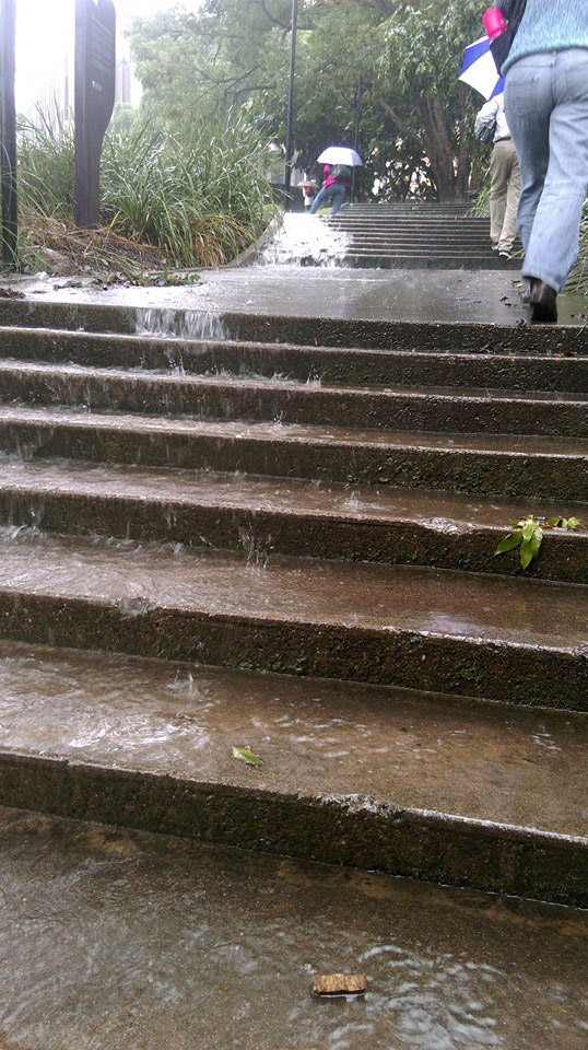
‘UQ Falls’ – posted to the Facebook group ‘UQ StalkerSpace’ by Panashé Machinguara just after midday on 1 May 2015.

‘A lot of rain’ is one way to describe what Brisbane experienced on Friday the 1st of May, 2015. ‘Extraordinary weather event’ would be another. The gauge in the CBD recorded 182mm of rain in the 24-hour period from 9am that morning. To put that in perspective, the historical average rainfall for the entire month of May is 74mm. The record for the largest daily fall at this time of year stands at 190mm on 26 April 1989, but the recent event set a new daily record for May, with the previous record being 149mm on 9 May 1980.1

Personally, I’d had enough of the rain long before any records were broken. My trip into the University of Queensland at St Lucia that morning took nearly two hours because of a track fault somewhere near Yeronga Station. ‘Local flooding’ was said to be the cause. I enjoyed the rain a lot more from the other side of my office window, but was forced to venture out again at around 4pm. By that time, every road and pathway on the campus was a raging torrent. Continue reading

Notes:

  1. All of this rainfall data is available from the Climate Data Online section of the Bureau of Meteorology website. The historical data comes from the the Brisbane Regional Office station (040214), which operated from 1840 until 1994, while the more recent data comes from the Brisbane station (040913), which commenced operating in 1999.

Let’s talk about the weather

A new page is coming soon, I promise! But while that is still in the wings, I thought this would be as good time as any to talk about the weather. Can anyone remember when it last rained? I can’t either, but according to the Bureau of Meteorology’s records, it was the 19th of July.1

Daily rainfall data from the Bureau of Meteorology (station 040913)

Daily rainfall data from the Bureau of Meteorology (station 040913)

That’s 45 consecutive rainless days, with more likely to come (the current forecast for each of the next seven days is “Fine, mostly sunny”). For the most part, the lawns and trees around the place aren’t looking too parched just yet — no doubt thanks to the relatively good rainfall we enjoyed during the first half of the year. But there are some clear signs that the landscape is drying up. A really good example is the pond straddling the bottom of Norman Buchan Park and the Government House grounds. Here’s what it looked like back in October of last year:

The pond on the Fernberg grounds

The pond on the Fernberg grounds (Government House), October 2011

The pond by the culvert under Baroona Road at Norman Buchan Park

The pond by the culvert under Baroona Road at Norman Buchan Park, October 2011


And here’s what it looked like as I passed by this morning on my way to the markets (note that I did not take these with a before-and-after comparison in mind, so the angles are different to the previous photos):

The pond at the bottom of the Fernberg grounds, 2 September, 2012.

The pond at the bottom of the Fernberg grounds, 2 September, 2012.

The pond at Norman Buchan Park, 2 September, 2012.

The pond at Norman Buchan Park, 2 September, 2012.


On the Norman Buchan Park side, there is but one small puddle remaining, while on the Fernberg side the water level has dropped significantly. How long before it dries out completely? I’ve been told by one keen observer that this pond did not completely dry up even during the millennium drought, which lasted from around 1997 until 2009.2 If that is the case then it seems likely that the pond receives water from a source other than the surface drainage from the surrounding hills. One possibility is that it is fed by an underground spring. This theory is lent weight by historical anecdotes such as J.C Heussler’s letter to the Lands Department in 1864 describing a permanent spring nearby, and John Oxley’s discovery in 1824 of a chain of ponds in the area in the midst of another severe drought (see here and here for more about Heussler’s and Oxley’s reports).

I hope the current dry spell does not last too much longer. But if it hasn’t rained before next Sunday, I’ll be sure to have another look on my way to the markets.

Notes:

  1. I’m not counting the 0.2mm that was recorded on 20 July or 1 September. These data are available from the Bureau’s web site.
  2. See here and here for some more information about the drought.