Uncovering Langsville Creek, Part 4 – Something to do with death

This is the fourth in a series of posts about Langsville Creek, which was Western Creek’s upstream neighbour on the Toowong/Milton Reach. Before reading this post, you may like to look at Part 1, Part 2 and Part 3 of the series.

Previously, on Uncovering Langsville Creek . . .

The first three episodes of this little mini-series have unfolded much like a daytime soap: the plot has thickened, but not much has happened. Well, without giving too much away, this is the episode where things happen. It is the murder-mystery end-of-season thriller. Characters will die, secrets will be revealed, and lost worlds discovered. But first, a brief recap.

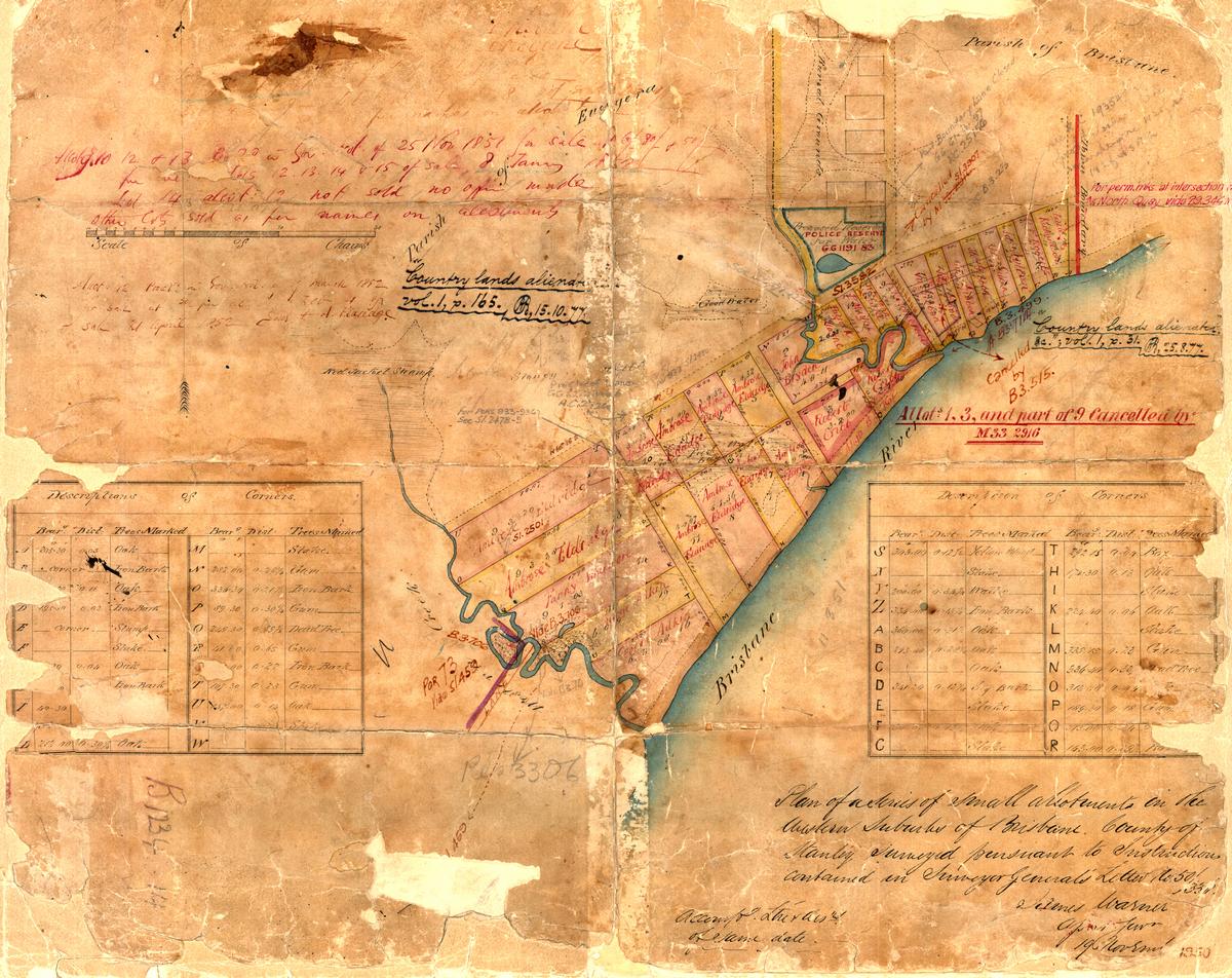
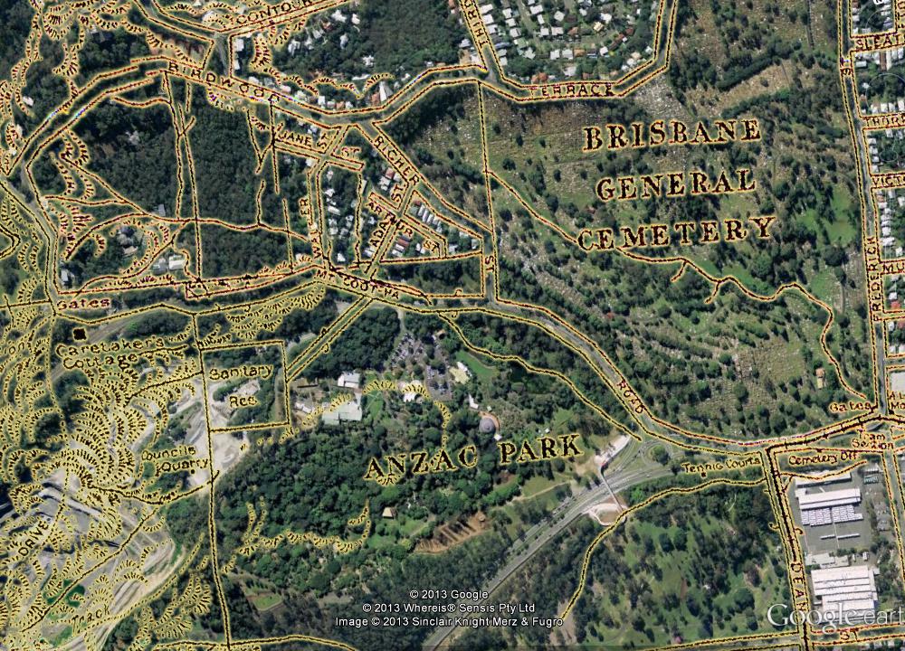
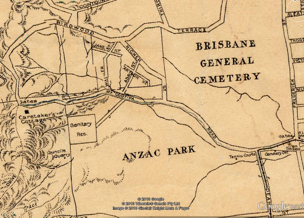
The previous episode introduced the map that you see below, which dates from 1929 and is the only one I have found that shows the upper reaches of Langsville Creek. We explored the stream that runs from the upper-left corner of the map into what is labelled as Anzac Park. Today, the area at the top-left is the Treetops on Birdwood estate, and the area labelled as Anzac Park is the Mount Coot-tha Botanic Gardens (hover your cursor over the image to see the modern landscape). In the slopes below Birdwood Terrace we found the headwaters of Langsville Creek more or less as they have always been — as gullies running through dry scrub. Immediately across the road, however, we found lush rainforest streams flowing into large lagoons, all part of the regulated water cycle of the botanic gardens.

Part of a map of Brisbane dating from 1929 (available online via Brisbane Images). The watercourses shown are the upper reaches of Langsville Creek. (Note that some distortions and artifacts emerged in preparing the map for Google Earth, most notably the giant crack running along Mount Coot-tha Road.)

At the end of the Western Freeway, where the entrance to the Legacy Way tunnel is still being built, the trail ran cold, and the Gardens stream came to an end. It is time, then, to move onto the other two streams — or one of them anyway, as I intend to drag this series out to a fifth installment (check back for it in six months or so). The stream we will look at today flows right through another of Toowong’s famous landmarks: the cemetery. Continue reading

The broken lands of Toowong

Note – many of the pictures in this post contain two images, which flip back forth when you hover your mouse over them. On a mobile device these images will switch when you touch them, and then switch back when you scroll away … if you are lucky. For best results, please view this article on a desktop or laptop.

A survey plan of the Milton area in about 1850 (B.1234.14), held by Queensland's Museum of Lands, Mapping and Surveying.

Figure 1. A survey plan of the Milton area in about 1850 (B.1234.14), held by Queensland’s Museum of Lands, Mapping and Surveying.

In an earlier post called The Waters of Milton, I explored a survey plan of Milton drawn in 1850 (Figure 1). Survey plans are valuable historical artifacts because they generally represent the first efforts to capture the landscape on paper. They reveal natural features that have long since vanished, such as creeks, swamps and even hills. They also provide insights into how the colonists saw the land, indicating its potential uses and specifying how it was to be divided up among its new owners.

Since writing that post, I have obtained several more digitised survey plans of the Milton Reach and Western Creek areas, thanks to the assistance of the Museum of Lands, Mapping and Surveying, which is part of the Queensland Department of Natural Resources and Mines. I look forward to featuring them all in articles in the future, but today I will explore just one of them. This particular plan carries the catalogue name of M.31.65. I have no idea what that means, but then there is a lot about these plans that I am still fuzzy about. Some of the surveying markings may as well be hieroglyphs to me, but thankfully there is much that can be gleaned even without specialist knowledge.

Unlike the Milton plan, this one depicts an area inland from the river. I’ll get to the precise area shortly, but first we need to dispense with some formalities.
Continue reading

Uncovering Langsville Creek, Part 3 – The Headwaters

This is the third in a series of posts about Langsville Creek, which was Western Creek’s upstream neighbour on the Toowong/Milton Reach. Before reading this, you may like to look at Part 1 and Part 2 of the series.

I started this series of articles about Langsville Creek as a distraction from my original mission of writing about Western Creek. My new interest soon produced another distraction when I stumbled across a dump of old bottles and cans while exploring Langsville Creek’s headwaters. When I finally finished writing about those bottles and cans a few months later, I took a holiday in Melbourne from which I returned with enough ideas about contrasting topographies to divert myself for several weeks more. Now, having gotten those ideas out of my system, I am resuming work on my first distraction so that some day in the near future I might return to my original goal.

This episode will be pick up the story in the same part of the creek as I got distracted in by those bottles and cans — its headwaters. Having mapped out Langsville Creek’s catchment in the last installment of the series, it is time now to trace where the water flows, and the logical place to start is where the water does: at the top.
Continue reading

Correction – Langsville Creek catchment area

Just a quick note to mention that I have just updated the recent post about the catchments of the Crescent Reach to include a revised outline of the Langsville Creek catchment.

My first attempt at mapping that catchment omitted an area between (roughly) Ascog Terrace and Kensington Terrace, and including Toowong Village. I thought this might have been a separate catchment that discharged straight to the river, but closer inspection showed that it was actually a subcatchment of Langsville Creek. The give-away was the fact that one of the branches of Langsville Creek as depicted on the map from 1859 reached a good distance into this area.

So, Toowong Village is part of the Langsville Creek catchment after all (in fact I suspect it was built right on top of a watercourse), and the area of the catchment is about 3.3 km2 rather than the 2.7 km2 that I think I estimated the first time around.

I have also updated the kmz file that you can use in Google Earth to explore the catchments.

Uncovering Langsville Creek — Part 1

This is the first in a series of posts about Langsville Creek, which was Western Creek’s upstream neighbour on the Toowong/Milton Reach. I do not intend to research Langsville Creek fully at this stage, as I have too much still to learn about Western Creek. But I couldn’t resist tracing the path of this (mostly) lost creek and seeing what can be learned by looking at the some of the old maps and aerial photographs. Each post will look at a different part of Langsville Creek. This one focuses on the lowest reaches of the creek, near where it met the Brisbane River. You can also now read Part 2 and Part 3 of the series.

The meanders of Moorlands

Toowong Cemetery … Anzac Park … the Mount Coot-tha Botanical Gardens … Quinn Park … the McIlwraith Croquet Club … Toowong Memorial Park … Moorlands Park.

What do all of these places have in common? The answer is a creek. Not a creek you are likely to have seen or heard of, for there are few traces of it left today. But there once was a creek that flowed through all of these locations.

The creek uniting these locations was known to early Brisbanites as Langsville Creek, though I imagine that it also had names given to it by the Turrbal people long before Europeans arrived. I’ve not read up on how and when it came to be known as Langsville Creek, but given that just about everything else in this part of Brisbane is named after John Dunmore Lang, I’m going to take a punt and guess that this creek was as well.

Langsville Bridge at Auchenflower, ca.1910. (State Library of Queensland, Negative no. 118279)

Langsville Bridge at Auchenflower, ca.1910. (State Library of Queensland, Negative no. 118279)

You can see Langsville Creek — or at least part of it — on the early maps of Brisbane. It’s depicted most clearly on McKellar’s 1895 map, the relevant portion of which is reproduced below. The creek itself is unnamed on this map, except by way of the bridge that crosses it where Patrick Lane meets the River Road (now Coronation Drive). The creek looks rather like an outgrowth of the river, as if the river has put out tentacles or feelers, each one meandering through the landscape much as the river winds its way to the bay. The land surrounding it appears to be mostly undeveloped, presumably because it was damp and flood-prone.

Continue reading