The Western Creek floodgate: a reality after 125 years

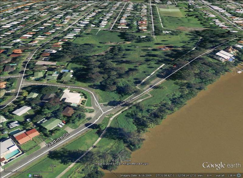
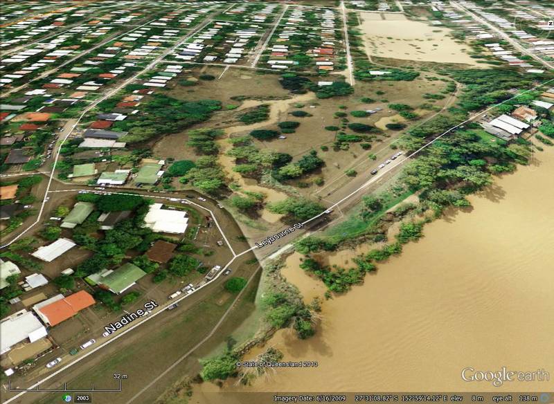
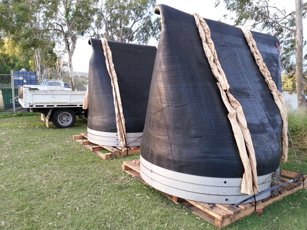
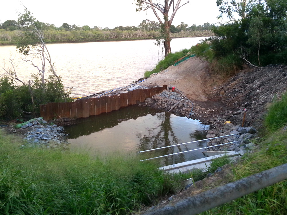
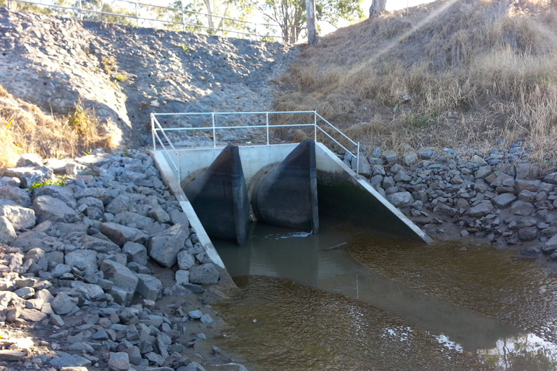
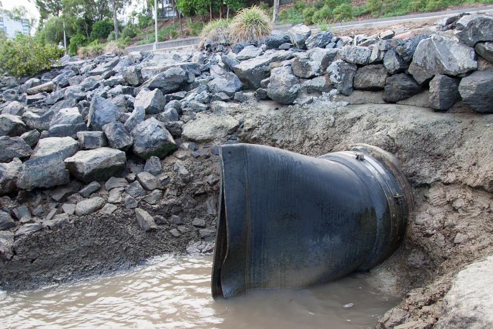
Way back in January, I reported that the City Council had begun constructing a floodgate at the mouth of Western Creek. This is the spot where the Milton Drain meets the river, right next to where the dilapidated shell of the old floating restaurant still stands. If you have passed by this spot in the last few months, you will have seen that the construction is complete: Western creek finally has its floodgate.

Hugh Bell's letter to the editor of the Brisbane Courier in July 1889, arguing for the use of tidal valves to prevent flooding in Milton and Rosalie.

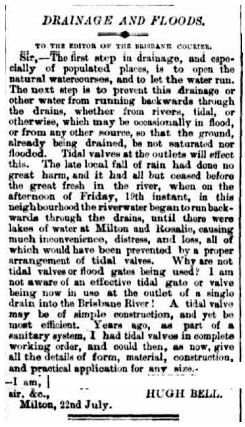
Hugh Bell’s letter to the editor of the Brisbane Courier in July 1889, arguing for the use of tidal valves to prevent flooding in Milton and Rosalie.

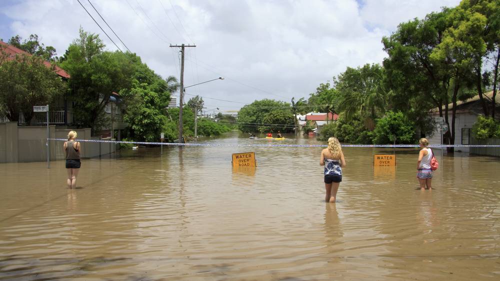
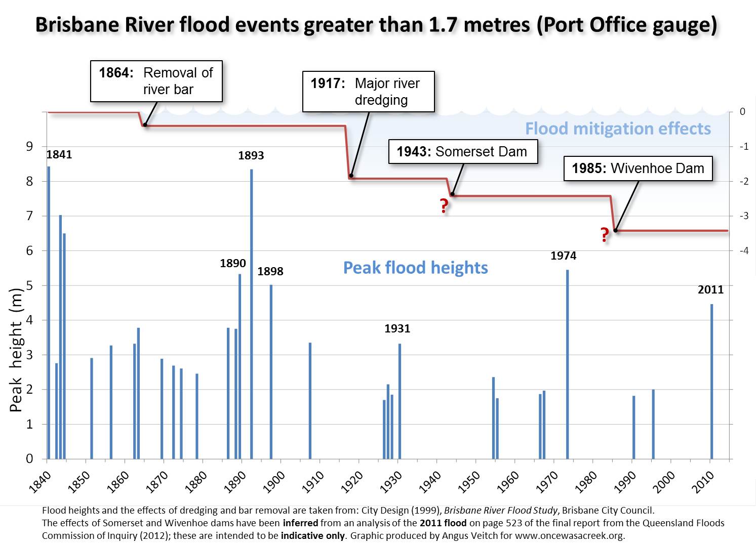
I say ‘finally’ not because more than three and a half years have passed since the 2011 flood (some people might even call that response time quick), but because more than 125 years have passed since a floodgate at the mouth of Western Creek was first proposed. In July 1889, while the mud was still drying from a flood that peaked at 3.75m on the Port Office gauge (about 2 ft lower than the 2011 flood), a Milton resident named Hugh Bell wrote to the Brisbane Courier, asking “Why are not tidal valves or flood gates being used” to prevent flooding in Milton, Rosalie and other low-lying suburbs? This question was no doubt raised again in March of the following year, when the river peaked at 5.33m — just under the mark of the 1974 flood. In response, the Toowong Shire Council in October 1890 unveiled an ambitious whole-of-shire1 drainage scheme which featured floodgates at the end of Western Creek and Langsville Creek. But the council could not afford to build the whole scheme, and so built it piecemeal instead. Some components, such as the drain through Red Jacket Swamp, took years to get finished, while the floodgates never materialised at all.

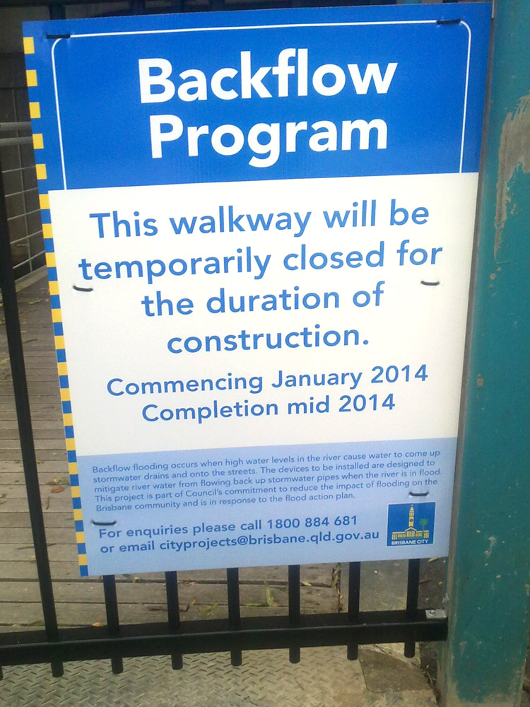
But the idea didn’t die: it resurfaced after every flood, only to recede again with the memory of the floodwaters. It probably sunk into near-oblivion after the completion in 1985 of Wivenhoe Dam, which — if you believed the real estate industry — was supposed to save Brisbane from ever flooding again. But when the flood in January 2011 proved — unless you believe the real estate industry — that Wivenhoe Dam is not a bottomless pit after all, attention turned once again to more localised methods of flood mitigation. The Brisbane City Council commissioned a study into backflow prevention, and since 2012 has been rolling out the installation of floodgates — more properly known as backflow prevention devices — at prioritised spots along the river. Continue reading

Notes:

  1. The Toowong Shire fronted the river all the way along the Milton Reach, from Boundary Creek (where Boomerang Street is today) to Toowong Creek (near Gailey Road). The boundary between Toowong and Ithaca shires began where the railway line crossed Boundary Creek, and continued along the railway until it reached Baroona Road, then known as the Boundary-road because it divided the two shires all the way up to the top of what is still called Boundary Road today. (Back then, Baroona and Boundary roads were joined at the upper end of Norman Buchan Park.)

The Duckbill Dimension

I wrote last week about the backflow prevention device — let’s call it a floodgate — that the council is installing at the end of the Milton Drain to protect the Western Creek drainage system from backflow flooding (that is, flooding from the river rather than from local stormwater). The Western Creek floodgate is the most recent — and probably the most ambitious — in a series of such works being done across Brisbane as part of the City Council’s Backflow Program.

Another place where a floodgate is presently being constructed is the outlet of the Leybourne Street drainage system in Chelmer. This system meets the river as a large open channel at Faulkner Park. There isn’t much of a creek left, and I don’t know what it used to be called. Evidently though, it flooded quite seriously in January 2011.

The end of the Leybourne Street drainage system in Chelmer, soon after the peak of the 2011 flood (note that a larger area was flooded — including the road — at the peak). Hover over the image (or tap it if you are using a tablet or smartphone) to see the normal landscape. Flood imagery from Queensland Globe.

Two large duckbill valves waiting to be installed near Leybourne Street, Chelmer.

Two large duckbill valves waiting to be installed near Leybourne Street, Chelmer.

I see this place several times a week because I ride past it on my way to work. For some weeks now there has been excavation work going on in the channel on both sides of the road. There have been tractors, trucks, fences, signs, portaloos, the whole works. In this last week, the stars of the show have arrived: two enormous duckbill valves.

Duckbill valves seem to be the City Council’s favoured backflow prevention device, as they are popping up everywhere. There are two already at Milton just downstream from the Western Creek system, and just last weekend I noticed one at Merthyr Park at Newfarm. But the specimens I have seen so far are all modestly sized — certainly less than a metre across. The two at Leybourne Street are of another scale altogether. Each of them must be nearly two metres wide, and in their current position on the grass they stand more than two metres tall (even at full stretch I could not reach their tops). They are made of some sort of very hard rubber-like material — so hard that I have trouble imagining it yielding even to a torrent of stormwater. But this is exactly what these devices have been designed to to, or else they would cause local flooding every time there is a downpour.

A temporary dam at the outlet of the Leybourne Street drainage system, where the duckbill valves will be installed.

A temporary dam at the outlet of the Leybourne Street drainage system, where the duckbill valves will be installed.

Looking over the embankment towards the river, you can see the new concrete structure into which these duckbills will be fixed. Curiously, the area in front of it has been made into a small temporary dam. I’m not sure why.

These devices will bring some comfort to residents in this area who were flooded in 2011. But it is worth being aware of their limitations. If you look closely at the Queensland Globe flood imagery (best done via Google Earth rather than the image above), you will notice that there is mud all over the road at Leybourne Street. This is a telltale sign that the river broke its banks here, flooding the area directly rather than just through the drains. Indeed, the river spilled over the banks for much of the length of the Chelmer Reach. This means that the two duckbill valves, as big as they are, will not protect this drainage system from a flood as high as 2011 unless the bank itself is raised. Even so, they will hold off the flood until the riverbank is breached, and should stop most floods that are below the 2011 mark.

These are not the sort of devices that I expect to see installed at Western Creek, where to have any real impact a floodgate will need to fill up the large space around the footbridge under Coronation Drive. But as the Backflow Program proceeds, I will be curious to see if any duckbills appear that are bigger than these two.

A sticker showing the manufacturer of the two big duckbill valves.

A sticker showing the manufacturer of the two big duckbill valves.

The tip of the duckbill valve.

The tip of the duckbill valve. The rubber is thick and hard, but will open up when there is enough water pressure behind it. We hope.

UPDATE – 11 August 2014

The duckbills have of course been in place for some time now, but I only recently got around to checking them out. When I visited, there was a small but constant stream of water trickling through one of the valves, as you can see in this short video.

The installed duckbill valves. If you look closely, you can see some water trickling through the one on the right.

The installed duckbill valves. If you look closely, you can see some water trickling through the one on the right.

A floodgate for Western Creek

A sign announcing the construction of a backflow valve at the mouth of Western Creek.

A sign announcing the construction of a backflow valve at the mouth of Western Creek. It is erected on the gate to the footbridge under Coronation Drive. (Photo: S. Cowley)

So, it’s really happening. If this sign is to be believed, then Western Creek is finally going to have its floodgate. The photo was snapped at the entrance to the footbridge under Coronation Drive at the mouth of Western Creek (otherwise known as the Milton Drain) a few weeks ago by Steven Cowley, who has been my eyes on the ground at Western Creek ever since I moved to the southside last year.

The sign doesn’t mention a floodgate, but that is essentially what the ‘devices to be installed’ as part of the ‘Backflow Program’ are. They are contraptions of varying designs that ‘mitigate river water from flowing back up stormwater pipes when the river is in flood’. Such devices have already been installed just downstream near Cribb Street and the Go-Between Bridge. The City Council’s website has a page listing all of the places where backflow devices have been, or might soon be, installed. The page also provides links to the technical reports about these devices that the council commissioned in the wake of the 2011 flood. Continue reading

Are we learning yet?

A story in the Brisbane Times this morning, titled Buyers less fearful of flood zones, made me a little bit mad.

Though I try not to buy into the blame game around the 2011 flood, I suspect that the real estate industry is partly responsible for the false sense of security that set in after Wivenhoe Dam was built. I have no proof of this; it is just a hypothesis. But it stands to reason that someone whose job is to sell houses will downplay the risks of flooding any way they can. Buyer beware.

Whether or not real estate agents have done it in the past, they certainly seem to be doing it now.

According to agents working in river precinct suburbs, the percentage of buyers willing to consider properties previously flooded in 2011 has increased significantly because they feel assured that the Wivanhoe Dam did its job in mitigating another flood over the Australia Day weekend.

Granted, this boost in buyers’ confidence is not necessarily the doing of real estate agents. People make their own assessments of risk based on events, and make their own decisions accordingly. Whether those assessments and decisions are justified or wise is an open question, but it is one that needs to be answered with some understanding of the facts about the 2011 and 2013 flood events, what role the dam played in each, and how the two events are comparable. I won’t pretend to have all of those facts. But I humbly suggest that not many real estate agents do either.

The article continues, quoting Brad Robson of Brisbane Real Estate:

“They’re happy that the dam worked. There was a truckload of rain and nothing flooded so it’s given them the confidence to go ahead and make a purchase”

John Johnston, of Johnston Dixon, said the Brisbane River needed a proposed class action by residents to succeed in order to clear its name.

“These properties should never have experienced the flooding that they did in 2011 and the latest weather event last month supports that,” he said.

“The mitigation capacity of the Wivanhoe have now been proven. I’m confident that if this class action goes through, it will largely clear the Brisbane River’s name and buyers will no longer be afraid to purchase near the river.”

Torwood Street during the January 2011 flood

Torwood Street during the January 2011 flood

There you have it: the smallness of the 2013 flood proves that the 2011 flood did not need to happen. It was all the fault of the dam operators. They are guilty, and the river is innocent — we just need to ‘clear its name’!

I’ll stress again that I do not know all of the relevant facts. But in case someone else has the inclination to go do some homework, I suggest that the following questions would be a good place to start:

  • Could it be that the 2013 flood was smaller than the 2011 flood because there was less rain?
  • Where did the “truckload of rain” that fell in 2013 actually fall? According to our Premier and the Bureau of Meteorology, the flooding in 2013 was caused by rain that fell in catchments that discharge to the Brisbane River downstream of Wivenhoe Dam. Suppose that even more rain (a shipload?) fell in those catchments: would the dam save us then?
  • Could there be any truth in the Flood Commission’s finding, stated on page 524 of the Commission’s final report, “that, allowing for the limits of the strategies in the Wivenhoe manual, the flood engineers achieved close to the best possible flood mitigation result for the January 2011 flood event”?

I’m not presuming that the dam manual is perfect, that the dam operators did a perfect job, or that there are not lessons to be learned from the way the 2011 flood was managed. And I’m not offering an opinion on whether a class action against the government’s management of the flood is warranted. But I do think that comments such as those above from the real estate industry are grossly irresponsible, and are the absolute last thing we need if we are to to learn from past events and become better informed about the nature of flood risks in Brisbane.

Buyer beware.

Here we go again . . .

I don’t know about you, but I didn’t expect to be seeing scenes like these just a couple of years after January 2011. (See the new Gallery page for more pictures of today’s flooding.)

Gregory Park, 28 January 2013. The tide was still rising, and water was gushing into the park through this drain.

Gregory Park, 28 January 2013. The tide was still rising, and water was gushing into the park through this drain.

Milton Drain, from the mystery building on Milton Park, 28 January 2013.

Milton Drain, from the mystery building on Milton Park, 28 January 2013.

Then again, we shouldn’t be surprised: there’s no reason why floods should be spaced out evenly over time. Indeed, the historical record of Brisbane’s floods suggests that they often come in twos or threes.

Flood events greater than 1.7m in the Brisbane River since 1841. Also shown are the estimated mitigating impacts of river works and the two dams. All data sourced from the Brisbane River Flood Study except the effect of the two dams, which is indicative only and has been inferred from an analysis on page 523 of the final report of the Flood Commission of Inquiry.

Flood events greater than 1.7m in the Brisbane River since 1841. Also shown are the estimated mitigating impacts of river works and the two dams. All data sourced from the Brisbane River Flood Study except the effect of the two dams, which is indicative only and has been inferred from an analysis on page 523 of the final report of the Flood Commission of Inquiry.

Meanwhile, just downstream . . .

A duckbill valve on the riverbank at Milton

A duckbill valve on the riverbank at Milton

I’m also guessing that the Brisbane City Council wasn’t expecting their new backflow prevention devices to be put to use so soon. As explained in my essay Backflow to the Future, the Council has recently installed duckbill valves and flap-gates to prevent flooding in several locations, including the Cribb Street drainage system in Milton. This area spans between Cribb Street and Park Road.

After my little adventure this morning I took a walk around this area and could see no evidence of flooding. Unless this whole area is higher up than the Western Creek area (which I do not believe to be the case), this means that the duckbills and flap-gates are doing their job.

If this is the case then the Council can give itself a pat on the back. And if it has any sense, the Council will look for ways to tell everyone how many properties these devices saved from being flooded. Then again, the Council may not want to create too much work for itself. Before long, every suburb in Brisbane will be wanting one of these duckbill thingies . . .