Up hill and down Dale: Where did Elizabeth drown?

In the fourth episode of Uncovering Langsville Creek, I told the story of Elizabeth Dale, who on 31 January 1905 drowned in a waterhole in the Toowong Cemetery. I was intrigued by the notion that there was once a waterhole in this otherwise dry and barren land, so I set about trying to determine its location. I failed dismally, but at least got some mileage out of reporting my misadventure. Thankfully, two readers took pity and provided me with some new leads. I am glad to report that having followed those leads, I can now reveal where Elizabeth drowned. I would only be more glad if no-one else had figured it all out before me.

A wild ghost chase

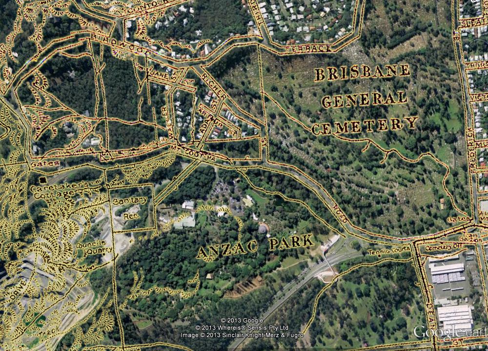
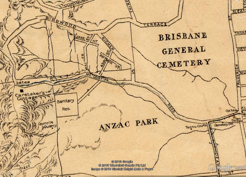
My first attempt to find the site of the waterhole was as optimistic as it was misguided. The only clue I had was that the waterhole was somewhere near the graves of Elizabeth’s husband and brother. Or at least, that was the inference I drew — incorrectly, it turns out — from statements given at the inquest into Elizabeth’s death saying that her body “was found off a pathway between her husband’s and brother’s graves” and that “the pool was about 20ft. from the pathway”. I assumed that the waterhole and Elizabeth’s husband’s and brother’s graves must have all been close to one another, and that I could deduce the location of the waterhole by finding the graves of a Dale and a Dodd (I didn’t even know their first names) in a low-lying part of the cemetery.

That mission was never likely to succeed. Many of the headstones in the low parts of the cemetery — especially those from the 19th century — were unreadable or missing altogether, and unless I spent all day looking, I was never going to check all of the readable ones anyhow. On the bright side, I had a pleasant afternoon and got some exercise. I felt a little foolish, however, when a reader named Ann Stephens pointed me to a much smarter way of finding graves in Brisbane: the City Council’s Grave Location Search, which enables you to find a grave by specifying the person’s name and the year they were buried. It’s kind of like a Yellow Pages for the deceased. Continue reading

Uncovering Langsville Creek, Part 4 – Something to do with death

This is the fourth in a series of posts about Langsville Creek, which was Western Creek’s upstream neighbour on the Toowong/Milton Reach. Before reading this post, you may like to look at Part 1, Part 2 and Part 3 of the series.

Previously, on Uncovering Langsville Creek . . .

The first three episodes of this little mini-series have unfolded much like a daytime soap: the plot has thickened, but not much has happened. Well, without giving too much away, this is the episode where things happen. It is the murder-mystery end-of-season thriller. Characters will die, secrets will be revealed, and lost worlds discovered. But first, a brief recap.

The previous episode introduced the map that you see below, which dates from 1929 and is the only one I have found that shows the upper reaches of Langsville Creek. We explored the stream that runs from the upper-left corner of the map into what is labelled as Anzac Park. Today, the area at the top-left is the Treetops on Birdwood estate, and the area labelled as Anzac Park is the Mount Coot-tha Botanic Gardens (hover your cursor over the image to see the modern landscape). In the slopes below Birdwood Terrace we found the headwaters of Langsville Creek more or less as they have always been — as gullies running through dry scrub. Immediately across the road, however, we found lush rainforest streams flowing into large lagoons, all part of the regulated water cycle of the botanic gardens.

Part of a map of Brisbane dating from 1929 (available online via Brisbane Images). The watercourses shown are the upper reaches of Langsville Creek. (Note that some distortions and artifacts emerged in preparing the map for Google Earth, most notably the giant crack running along Mount Coot-tha Road.)

At the end of the Western Freeway, where the entrance to the Legacy Way tunnel is still being built, the trail ran cold, and the Gardens stream came to an end. It is time, then, to move onto the other two streams — or one of them anyway, as I intend to drag this series out to a fifth installment (check back for it in six months or so). The stream we will look at today flows right through another of Toowong’s famous landmarks: the cemetery. Continue reading

The broken lands of Toowong

Note – many of the pictures in this post contain two images, which flip back forth when you hover your mouse over them. On a mobile device these images will switch when you touch them, and then switch back when you scroll away … if you are lucky. For best results, please view this article on a desktop or laptop.

A survey plan of the Milton area in about 1850 (B.1234.14), held by Queensland's Museum of Lands, Mapping and Surveying.

Figure 1. A survey plan of the Milton area in about 1850 (B.1234.14), held by Queensland’s Museum of Lands, Mapping and Surveying.

In an earlier post called The Waters of Milton, I explored a survey plan of Milton drawn in 1850 (Figure 1). Survey plans are valuable historical artifacts because they generally represent the first efforts to capture the landscape on paper. They reveal natural features that have long since vanished, such as creeks, swamps and even hills. They also provide insights into how the colonists saw the land, indicating its potential uses and specifying how it was to be divided up among its new owners.

Since writing that post, I have obtained several more digitised survey plans of the Milton Reach and Western Creek areas, thanks to the assistance of the Museum of Lands, Mapping and Surveying, which is part of the Queensland Department of Natural Resources and Mines. I look forward to featuring them all in articles in the future, but today I will explore just one of them. This particular plan carries the catalogue name of M.31.65. I have no idea what that means, but then there is a lot about these plans that I am still fuzzy about. Some of the surveying markings may as well be hieroglyphs to me, but thankfully there is much that can be gleaned even without specialist knowledge.

Unlike the Milton plan, this one depicts an area inland from the river. I’ll get to the precise area shortly, but first we need to dispense with some formalities.
Continue reading

Exploring McKellar’s map in Google Earth

The fun with maps continues…

As detailed in last week’s post, I have recently been experimenting with ways of importing historical maps into Google Earth, which enables them to be explored from a whole new perspective. I initially did this for three maps, dating from 1843, 1859 and 1864. Today I’ve done the same for another map — Sheet 7 from a series of maps drawn by the government lithographer A.R. McKellar in 1895. This map shows the Milton Reach of the river and the area to the west up to Mount Coot-tha. You can see what the original version of this map looks like at the Queensland Historical Atlas.

You would already be familiar with this map’s depiction of Western Creek — it is the one shown at the top of this page and all throughout this website. The picture below shows this same part of McKellar’s map in Google Earth. Dunmore Park is in the foreground, and Milton Park, Frew Park and Gregory Park can also be seen along the creek’s path.

Western Creek as depicted on McKellar's 1895 map, viewed in Google Earth.

Western Creek as depicted on McKellar’s 1895 map, viewed in Google Earth.

The image below shows the Toowong Cemetery. Beyond the cemetery, towards the upper right of the picture, is the area bounded by Boundary Road, Simpsons Road and Macgregor Terrace. This subcatchment of Western Creek is marked on McKeller’s map as the Lizzy Lee, Soudan and Rose Hill estates — names that all seem to have been lost, with the exception of Soudan Street. To the left of the cemetery, a ‘school reserve’ is marked on an area that is still bushland today.

The Toowong Cemetery as depicted on McKellar’s 1895 map. Further in the distance are the Lizzy Lee, Soudan and Rose Hill estates.

The Toowong Cemetery as depicted on McKellar’s 1895 map. Further in the distance are the Lizzy Lee, Soudan and Rose Hill estates.

McKellar’s map also depicts part of Ithaca Creek, the catchment of which neighbours the Western Creek catchment. The picture below shows two branches of Ithaca Creek meeting near Carwoola Street. In the immediate foreground, under the name ‘Glenalbro’, you can see the roof of the old Freers chip factory. At the lower-right of the picture is Purtell Park, and right on top of it is the creek as it appears in McKellar’s map. I’ve know this spot for all of my life, but I never realised until now that the path of the creek had been changed to make way for the park.

Part of Ithaca Creek as depicted on McKellar's 1895 map. At the lower-right of the picture, the old path of the creek can be seen over Purtell Park.

Part of Ithaca Creek as depicted on McKellar’s 1895 map. At the lower-right of the picture, the old path of the creek can be seen over Purtell Park.

To explore McKellar’s map for yourself, all you need to do is download either of the following files and open it in Google Earth (you will need to download and install Google Earth first if you haven’t already). The first file shows McKellar’s map features in yellow but without any shadow effect. The second file is the same, but includes the shadow effect that you can see in the images above. The first file is much smaller and will load quicker, but some features on the map will not be as easy to see without the shadow.

Have fun!