Tiger, brandy, oyster saloon: A new way to read the Brisbane Courier

It’s reboot time! It’s been eighteen months since I last posted here, and four years since I started my PhD. But my thesis now is nearly out of the way, which means I can return to more recreational forms of writing. It also means I can unveil what I have been working on to keep myself sane during the final stages of my PhD. In case I never fully explained, my PhD was about the application of a computational text analysis technique called topic modelling within social science. Basically, I spent the last four years learning how to do useful things with large amounts of textual data — a practice known as text mining or text analytics. Along the way, I also spent time experimenting with ways of putting textual data on a map. You can see some of the early results in my other blog, which for the last couple of years has been just as neglected as this one.

The methods I explored in my thesis were all based on a dataset of news articles and other texts about coal seam gas development, which has been a touchy topic in recent years in Australia. But I never forgot about my local history blog, and I always hoped to return to it armed with a new bag of tricks. And now here I am, with bag in hand.

Cultural cartography

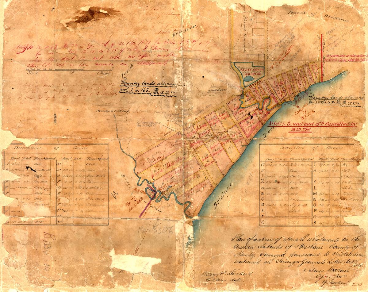
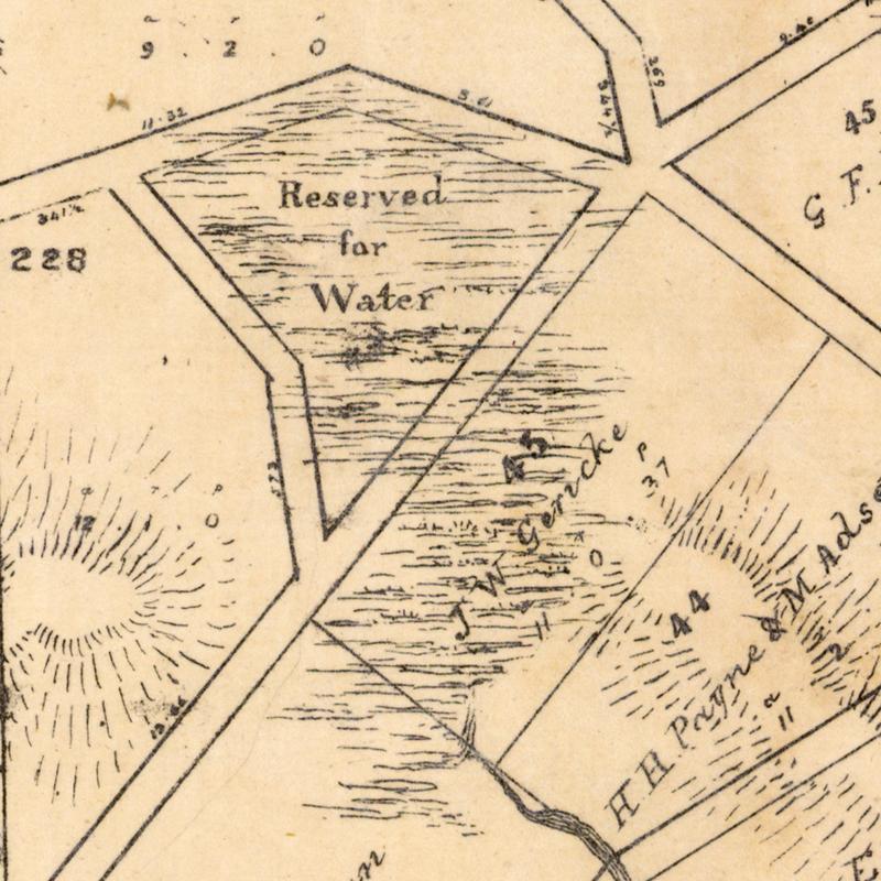
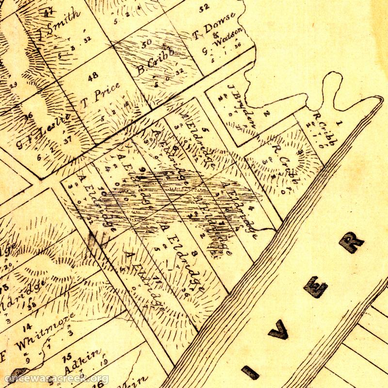
If you’ve spent any time exploring this site, you’ll know that I’m fond of projecting old maps and plans onto the modern landscape as a way of seeing how things have changed. I’ve done this by photoshopping the maps to extract the details and then loading the results into Google Earth, where they can be explored immersively and in three dimensions.

Langsville Creek as depicted in 1859, overlaid on the present-day landscape.

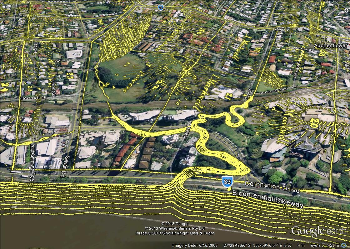
Figure 1. Langsville Creek as depicted in 1859, overlaid on the present-day landscape.

Continue reading

The history of the Coronation Drive Office Park

This post is all about the part of Milton bounded by the railway, Cribb Street, Coronation Drive and Boomerang Street. If you live in Brisbane, it’s a place that you have probably passed many times without really noticing. From Coronation Drive it presents as a row of office buildings and some Jacarandas; from the train, as a car park and some Moreton Bay figs. From within, the site feels like a secluded, shady village. Interspersed with the eight office buildings and fig trees are a tennis court, a childcare centre, a multi-level carpark, an open carpark, cafes, and various shops including a Flight Centre and a real estate office. This site is known (to those who know it as anything at all) as the Coronation Drive Office Park.

The Coronation Drive Office Park is bounded by Cribb Street, the railway line, Boomerang Street and Coronation Drive.

The Coronation Drive Office Park covers 4.5 hectares and is bounded by Cribb Street, the railway line, Boomerang Street and Coronation Drive.

AMP Capital, which manages of the majority of the site,1 are considering the next stage of its development. Before commencing this development, AMP Capital wanted to learn more about the site’s past. They asked me if I would like to do some research, and I jumped at the opportunity. After several weeks plumbing the depths of Trove, the Brisbane City Archives and various other sources, I produced a report documenting the history of the Coronation Drive Office Park.

You can download the report here (it’s about 13MB — apologies for the big download), but for a shorter, more web-friendly version of the story, read on below. Continue reading

Notes:

  1. Except for half a hectare at the corner of Coronation Drive and Cribb Street, the site is owned by AMP and Sunsuper.

The legend of the lost lagoon

If you’ve read my earlier post about the Waters of Milton, then you will have already encountered this story, but I’d like to give it a post of its own. It’s the story of a lagoon that existed in the area bounded by Cribb Street, Park Road, Coronation Drive and the railway line — just outside the catchment of Western Creek. The lagoon stretched diagonally across this area from just near the Suncorp Bank on Park Road to where Cribb Street meets Coronation Drive.

The image below shows how the lagoon was depicted by the surveyor James Warner in 1850 on what is possibly the earliest map of the area. Immediately below the map is a screenshot from Google Earth, into which I imported an overlay of Warner’s map. It doesn’t exactly stand out, but if you look closely you can see the lagoon stretched across the modern landscape. In the background, you can also see Boundary Creek snaking through the Coronation Drive Office Park and past Suncorp Stadium.

The lagoon between Cribb Street and Park Road, Mitlon, as depicted in 1850.

A lagoon between Cribb Street and Park Road, Mitlon, as depicted in 1850.

The lagoon that once stretched between Cribb Street and Park road, as depicted on a map from 1850.

The lagoon that once stretched between Cribb Street and Park road, as depicted on a map from 1850.

Continue reading

The Waters of Milton

I’ve expressed previously my enthusiasm for old maps. The older they are, the more they tend to reveal about the original landscape.

Until recently, the oldest map that I had found of the Milton area dated back to 1859. That map (‘Plan of Portions 203 to 257 in the Environs of Brisbane, Parish of Enoggera, County of Stanley, New South Wales) covers the area between Boundary Creek (which flowed between Cribb Street and Boomerang Street) and Toowong Creek. It depicts several features I had not seen on other maps, such as Red Jacket Swamp spilling over into Frew Park (later maps just show it covering Gregory Park) and a large lagoon between Cribb Street and Park Road.

But now I have an even older one, courtesy of Magnus, who writes the blog ‘A House in Auchenflower‘. Magnus went digging in the Queensland Museum of Lands, Mapping and Surveying and struck gold in the form of the map you see below.

Surveyor James Warner's plan of the Milton area in 1850, held by the Queensland Museum of Lands, Mapping and Surveying (B1234 14).

Surveyor James Warner’s plan of the Milton area in 1850, held by the Queensland Museum of Lands, Mapping and Surveying (B1234 14).

This map looks old enough to have fallen off a pirate ship. The various annotations on it show that it has been used and re-used for various purposes, and at different times, but the original drawing appears to date from 1850, when the assistant surveyor-general, James Warner, surveyed the area. Warner’s description of the map appears at the bottom-right corner: Continue reading

Here we go again . . .

I don’t know about you, but I didn’t expect to be seeing scenes like these just a couple of years after January 2011. (See the new Gallery page for more pictures of today’s flooding.)

Gregory Park, 28 January 2013. The tide was still rising, and water was gushing into the park through this drain.

Gregory Park, 28 January 2013. The tide was still rising, and water was gushing into the park through this drain.

Milton Drain, from the mystery building on Milton Park, 28 January 2013.

Milton Drain, from the mystery building on Milton Park, 28 January 2013.

Then again, we shouldn’t be surprised: there’s no reason why floods should be spaced out evenly over time. Indeed, the historical record of Brisbane’s floods suggests that they often come in twos or threes.

Flood events greater than 1.7m in the Brisbane River since 1841. Also shown are the estimated mitigating impacts of river works and the two dams. All data sourced from the Brisbane River Flood Study except the effect of the two dams, which is indicative only and has been inferred from an analysis on page 523 of the final report of the Flood Commission of Inquiry.

Flood events greater than 1.7m in the Brisbane River since 1841. Also shown are the estimated mitigating impacts of river works and the two dams. All data sourced from the Brisbane River Flood Study except the effect of the two dams, which is indicative only and has been inferred from an analysis on page 523 of the final report of the Flood Commission of Inquiry.

Meanwhile, just downstream . . .

A duckbill valve on the riverbank at Milton

A duckbill valve on the riverbank at Milton

I’m also guessing that the Brisbane City Council wasn’t expecting their new backflow prevention devices to be put to use so soon. As explained in my essay Backflow to the Future, the Council has recently installed duckbill valves and flap-gates to prevent flooding in several locations, including the Cribb Street drainage system in Milton. This area spans between Cribb Street and Park Road.

After my little adventure this morning I took a walk around this area and could see no evidence of flooding. Unless this whole area is higher up than the Western Creek area (which I do not believe to be the case), this means that the duckbills and flap-gates are doing their job.

If this is the case then the Council can give itself a pat on the back. And if it has any sense, the Council will look for ways to tell everyone how many properties these devices saved from being flooded. Then again, the Council may not want to create too much work for itself. Before long, every suburb in Brisbane will be wanting one of these duckbill thingies . . .