Spreading the word

The oncewasacreek.org flyer. (Please download the PDFversion if you wish to use it.)

The oncewasacreek.org flyer. (Please download the PDFversion if you wish to use it.)

Having concentrated for so long on getting this site up and running and populating it with some content, I’ve recently turned my attention to getting the word out so that people might actually read it. That was, after all, the point of creating it in the first place.

Self-promotion has never come naturally to me, so I’m starting small. I’ve created a ‘flyer’ for the site that I have been posting around the neighbourhood on noticeboards, bus stops and the like. Perhaps you are here now because you stumbled across one of these.
If you would like to promote the site, and have (legitimate) access to a noticeboard or similar advertising space (perhaps in your workplace or school, for example), you are welcome to download and post the flyer. If you want to go that extra mile, you can even cut the tabs at the bottom so that they can be easily torn off.

Of course, you can always tell your friends, family and neighbours about the site the old-fashioned way as well!

John Oxley Centre Renovations

The courtyard of the John Oxley Centre, Coronation Drive, Decmber 2012

The courtyard of the John Oxley Centre, Coronation Drive, Decmber 2012

I took a walk down to the river this afternoon, and noticed that the John Oxley Centre, the office block standing over the mouth of Milton Drain, is undergoing some pretty substantial renovations. The courtyard, in which there used to be gardens featuring plaques engraved with excerpts from John Oxley’s fieldbook describing his landing hereabouts in 1824, has been completely gutted, the pavement and gardens all torn out.

I’d been meaning to get back there and photograph those plaques more thoroughly, but it looks like I might have missed my chance. That is, unless they are incorporated into the redeveloped courtyard. I thought those plaques were a nice touch, some small consolation for the fact that an office block now has been built over the lowest reach of this historic creek. It would be a shame if the some acknowledgement of the Creek and/or John Oxley’s landing is not featured in the new development.

Does anyone know the purpose of the renovations, or what we can expect to see when they are complete?

An extract from John Oxley's field book in the courtyard at the John Oxley Centre

An extract from John Oxley's field book in the courtyard at the John Oxley Centre

When it really rains

La Nina has now officially left us, and already the Bureau is watching for signs of what next summer will bring. The summer of 2011-12 certainly was wet, but for the most part it was also rather gentle. Nearly all of the 700mm or so of rain that fell in Brisbane from the start of December 2011 to the end of February 2012 was delivered in doses of less than 50mm in a day. The one marked exception to this pattern occurred in the lead-up to Australia Day, with 187mm falling in the 24 hours before 9am, 26 January 2012.

Daily rainfall at the Mt Coot-tha Botanic Gardens, December 2011 to February 2012. (Bureau of Meteorology, Climate Data Online)

Daily rainfall at the Mt Coot-tha Botanic Gardens, December 2011 to February 2012. (Bureau of Meteorology, Climate Data Online)

Most of that rain fell on Wednesday 25 January, and I remember watching it from the comfort of my desk at 400 George Street. As I gazed out through the floor-to-ceiling windows, I also remember thinking about how the streams at the top of Western Creek must have been gushing; I was anxious to get up there and take some photos. Having observed how quickly that part of the catchment tends to drain, I wanted to get there as soon as possible after a good fall of rain. The opportunity finally came on the morning of Sunday the 29th. The rain had eased after a fall of about 25mm overnight, so I donned my camera and my raincoat and hot-footed it up to the Weedy Wonderland at the top of Western Creek.

Daily rainfall at the Mount Coot-tha Botanic Gardens in January 2012

Daily rainfall at the Mount Coot-tha Botanic Gardens in January 2012

Needless to say, the rain resumed as soon as I got to Couldrey Street. Nursing my Canon 50D under the front zip of my raincoat, and whipping it out as briefly as I could to take photos, I trundled up the stream and through the scrub, clambering to vantage points that I’m sure no sane person would, all in the name of documenting Western Creek in full flow. Well, almost full flow, as it was clear that the water had been been significantly higher in the hours before I got there.

The results are in this gallery page, and there is a sneak preview just below.

I hope it was all worth it, because despite my efforts to dry out my camera gear when I returned home (this included a very slow bake in the oven for a couple of hours), I recently discovered that one of my lenses has succumbed to a fungal infection. And believe it or not, this lens was a replacement for another lens that met a similar fate after I dropped it (and the camera — and myself!) into the floodwaters at Torwood Street in January 2011. Folks, water and SLR cameras are not a good mix.

One of the streams leading to the Couldrey Street clearing, 29 January 2012

One of the streams leading to the Couldrey Street clearing, 29 January 2012

The Couldrey Street clearing, 29 January 2012

The Couldrey Street clearing, 29 January 2012


The Tristania Falls, 29 January 2012

The Tristania Falls, 29 January 2012

The drain at Norman Buchan Park, 29 January 2012

The drain at Norman Buchan Park, 29 January 2012


Time and tides

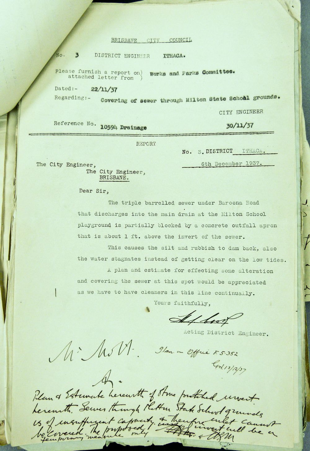
In John Oxley and the chain of ponds, I questioned whether Oxley could have found freshwater ponds downstream from Gregory Park, given that this part of the Western Creek is subject to regular inundation by the brackish tidal waters of the river. The tidal limit of the creek (or at least the drain) is no longer visible, being hidden somewhere underneath Frew Park, Gregory Park, or even further upstream. An article from The Brisbane Courier in 1896 reveals that tidal waters were entering Red Jacket Swamp, where they “killed the vegetation, and so caused it to fester and give off unhealthy odours”.1 Correspondence between Council engineers in the 1930s shows that at that time the tide even reached underneath Baroona Road.

But what about in 1824, when Oxley visited? Could it have been much different then? Since Oxley’s time, the river bed has been extensively dredged, and the bar at the river mouth cut away. Some of the narrower channels have been widened, and most of the riverbank (except in the upper reaches) has been cleared. Changes such as these, particularly the dredging and cutting of the bar, can be expected to affect the tidal dynamics of the river. The question is, how, and how much? Might the tidal limit of Western Creek have been very different in 1824 to what it is now, or even what it was in 1896 (given that dredging began in the 1860s2)?

The Wikipedia page for the Brisbane River, citing the 2001 State of South-east Queensland Waterways Report,3 states that “Historically, the Brisbane River contained upstream bars and shallows and had a natural tidal limit of only 16 km. The current tidal limit now extends 85 km upstream due to continual channel dredging”. If this is true, then the tidal dynamics of the river have changed dramatically indeed.

I’d really love to hear from someone with some insights, or even just some leads, regarding how these changes might have affected the tidal limit of Western Creek. Three things do make me wonder if whether it was indeed lower than Gregory Park. First, there is the way this part the creek is typically drawn on the old maps. The section from McKellar’s 1895 map shown below is a good example. Through the flats of Milton the creek is wide and winding, much like the river itself. Then after it crosses Milton Road, it thins and straightens as it enters Red Jacket Swamp. Second, there is the quote above from The Brisbane Courier, describing how the tidal water killed the vegetation in Red Jacket Swamp. If the swamp was naturally (i.e. historically) tidal, wouldn’t the vegetation in it be adapted to the salty water? And third, Red Jacket Swamp (Gregory Park) is marked on some of the early maps as ‘Water Reserve’. I’m not sure if this means it was seen as a potential water supply, or merely that it was a waterlogged chunk of government-owned land. If it was the former, then surely this land can’t have been much affected by the tides. Can somebody help??

A section of McKellar's 1895 map of Brisbane (retrieved from the Queensland Historical Atlas)

A section of McKellar's 1895 map of Brisbane (retrieved from the Queensland Historical Atlas)

The tides of Toowong

Just over a week ago I took a trip to Toowong Creek, where at Perrin Park you can see a “natural” mangrove-lined channel (though it is clearly not the original channel) giving way to a freshwater stream. The tide was low at the time, but I inferred (okay, guessed) its reach from the character of the vegetation and the quality of the water. Then quite fortuitously, while at the State Archives just the other day, I found a map made by the Queensland Survey Office in 1901 titled “Sketch plan showing position of bridge over Toowong Creek”,4 a portion of which is shown below.

Part of a sketch from 1901 indicating the tidal limit of Toowong Creek (Queensland State Archives Item ID620230)

Part of a sketch from 1901 indicating the tidal limit of Toowong Creek (Queensland State Archives Item ID620230)

Near the centre of the picture is the label “Tidal limit”, pointing to a line drawn across the creek. How does it compare to where it is today? By my reckoning, the limit today is somewhere near the hairpin bend just after the word “Toowong” on the map above. (I will report back once I have actually visited at high tide!) This is about 200 metres further upstream (as the crow flies) than the limit marked on the 1901 sketch.

What does this mean? I’m not sure, since we are not even comparing the same channel. As well as being straighter, the channel through the park today could well be deeper than the old one, which would result in the tide coming further upstream. Without knowing these sorts of specifics, it is hard to draw anything conclusive from this observation. Interesting though, isn’t it?

Notes:

  1. The Brisbane Courier, 24 July 1896, p7.
  2. G.R.C. Mcleod, “A short history of the dredging of the Brisbane River, 1860 to 1910”. This document is available online, and appears to be a chapter of a book, but unfortunately I cannot tell which book this is.
  3. Ivan Holland, Paul Maxwell and Angela Grice, ‘Tidal Brisbane River’, Chapter 12 in State of South-east Queensland Waterways Report 2001, Moreton Bay Waterways and Catchments Partnership, p.75.
  4. Queensland State Archives Item ID620230

The pond is not the spring

Today’s lesson: always go back to the source.

One of the intriguing leads that I came across when I started my research was a letter to the Department of Land and Works from J.C. Heussler, the first owner of Fernberg (Government House). Well, actually I didn’t come across the letter. Rather, I found a quotation of it in Allan Miles’ History of Rosalie1. Miles had found it in the State Archives, probably after many hours spent patiently perusing the correspondence files of various old departments. As Miles explained, the letter accompanied a petition from local land owners, residents and farmers, requesting the improvement of a road (what is now Caxton Street and Given Terrace) through the cemetery reserve (the swamp where Suncorp Stadium is today), and the formation of a water reserve “at the Red Jacket Swamp . . . where there is a spring of the purest water upon which the inhabitants (some hundreds, and daily increasing) have been entirely dependent during the late drought”.

The pond on the Fernberg grounds

The pond on the Fernberg grounds (Governor’s House), October 2011

Miles remarked that “some of the details referred to on the map are not legible”, which I took to mean that the location of the proposed water reserve probably was no longer visible. I always intended to check it out for myself, but life, and the rest of the website, moved on. Given that Heussler was the author of the letter, and the fact that even today there is a permanent pond where Western Creek once crossed the Fernberg grounds, I surmised that the spring in question might have been on the same property, perhaps even the very same pond. I even based a substantial part of my essay about John Oxley and the chain of ponds on this assumption.
Continue reading

Notes:

  1. Allan Miles (1978), A History of Rosalie, Eastwood, NSW