Let’s talk about the weather

A new page is coming soon, I promise! But while that is still in the wings, I thought this would be as good time as any to talk about the weather. Can anyone remember when it last rained? I can’t either, but according to the Bureau of Meteorology’s records, it was the 19th of July.1

Daily rainfall data from the Bureau of Meteorology (station 040913)

Daily rainfall data from the Bureau of Meteorology (station 040913)

That’s 45 consecutive rainless days, with more likely to come (the current forecast for each of the next seven days is “Fine, mostly sunny”). For the most part, the lawns and trees around the place aren’t looking too parched just yet — no doubt thanks to the relatively good rainfall we enjoyed during the first half of the year. But there are some clear signs that the landscape is drying up. A really good example is the pond straddling the bottom of Norman Buchan Park and the Government House grounds. Here’s what it looked like back in October of last year:

The pond on the Fernberg grounds

The pond on the Fernberg grounds (Government House), October 2011

The pond by the culvert under Baroona Road at Norman Buchan Park

The pond by the culvert under Baroona Road at Norman Buchan Park, October 2011


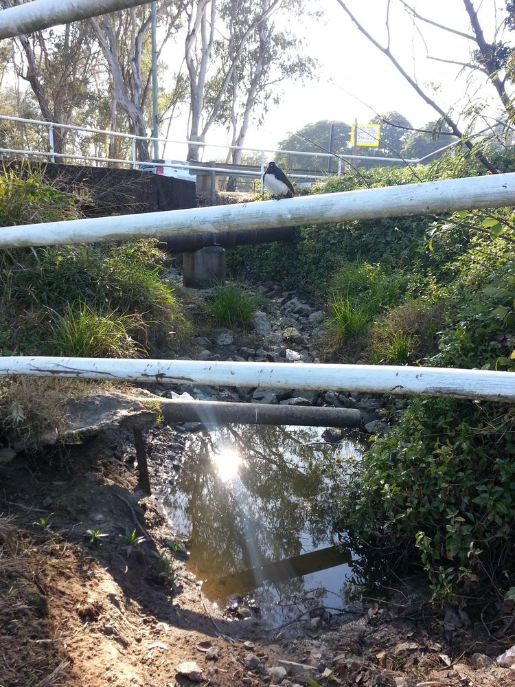
And here’s what it looked like as I passed by this morning on my way to the markets (note that I did not take these with a before-and-after comparison in mind, so the angles are different to the previous photos):

The pond at the bottom of the Fernberg grounds, 2 September, 2012.

The pond at the bottom of the Fernberg grounds, 2 September, 2012.

The pond at Norman Buchan Park, 2 September, 2012.

The pond at Norman Buchan Park, 2 September, 2012.


On the Norman Buchan Park side, there is but one small puddle remaining, while on the Fernberg side the water level has dropped significantly. How long before it dries out completely? I’ve been told by one keen observer that this pond did not completely dry up even during the millennium drought, which lasted from around 1997 until 2009.2 If that is the case then it seems likely that the pond receives water from a source other than the surface drainage from the surrounding hills. One possibility is that it is fed by an underground spring. This theory is lent weight by historical anecdotes such as J.C Heussler’s letter to the Lands Department in 1864 describing a permanent spring nearby, and John Oxley’s discovery in 1824 of a chain of ponds in the area in the midst of another severe drought (see here and here for more about Heussler’s and Oxley’s reports).

I hope the current dry spell does not last too much longer. But if it hasn’t rained before next Sunday, I’ll be sure to have another look on my way to the markets.

Notes:

  1. I’m not counting the 0.2mm that was recorded on 20 July or 1 September. These data are available from the Bureau’s web site.
  2. See here and here for some more information about the drought.

When it really rains

La Nina has now officially left us, and already the Bureau is watching for signs of what next summer will bring. The summer of 2011-12 certainly was wet, but for the most part it was also rather gentle. Nearly all of the 700mm or so of rain that fell in Brisbane from the start of December 2011 to the end of February 2012 was delivered in doses of less than 50mm in a day. The one marked exception to this pattern occurred in the lead-up to Australia Day, with 187mm falling in the 24 hours before 9am, 26 January 2012.

Daily rainfall at the Mt Coot-tha Botanic Gardens, December 2011 to February 2012. (Bureau of Meteorology, Climate Data Online)

Daily rainfall at the Mt Coot-tha Botanic Gardens, December 2011 to February 2012. (Bureau of Meteorology, Climate Data Online)

Most of that rain fell on Wednesday 25 January, and I remember watching it from the comfort of my desk at 400 George Street. As I gazed out through the floor-to-ceiling windows, I also remember thinking about how the streams at the top of Western Creek must have been gushing; I was anxious to get up there and take some photos. Having observed how quickly that part of the catchment tends to drain, I wanted to get there as soon as possible after a good fall of rain. The opportunity finally came on the morning of Sunday the 29th. The rain had eased after a fall of about 25mm overnight, so I donned my camera and my raincoat and hot-footed it up to the Weedy Wonderland at the top of Western Creek.

Daily rainfall at the Mount Coot-tha Botanic Gardens in January 2012

Daily rainfall at the Mount Coot-tha Botanic Gardens in January 2012

Needless to say, the rain resumed as soon as I got to Couldrey Street. Nursing my Canon 50D under the front zip of my raincoat, and whipping it out as briefly as I could to take photos, I trundled up the stream and through the scrub, clambering to vantage points that I’m sure no sane person would, all in the name of documenting Western Creek in full flow. Well, almost full flow, as it was clear that the water had been been significantly higher in the hours before I got there.

The results are in this gallery page, and there is a sneak preview just below.

I hope it was all worth it, because despite my efforts to dry out my camera gear when I returned home (this included a very slow bake in the oven for a couple of hours), I recently discovered that one of my lenses has succumbed to a fungal infection. And believe it or not, this lens was a replacement for another lens that met a similar fate after I dropped it (and the camera — and myself!) into the floodwaters at Torwood Street in January 2011. Folks, water and SLR cameras are not a good mix.

One of the streams leading to the Couldrey Street clearing, 29 January 2012

One of the streams leading to the Couldrey Street clearing, 29 January 2012

The Couldrey Street clearing, 29 January 2012

The Couldrey Street clearing, 29 January 2012


The Tristania Falls, 29 January 2012

The Tristania Falls, 29 January 2012

The drain at Norman Buchan Park, 29 January 2012

The drain at Norman Buchan Park, 29 January 2012