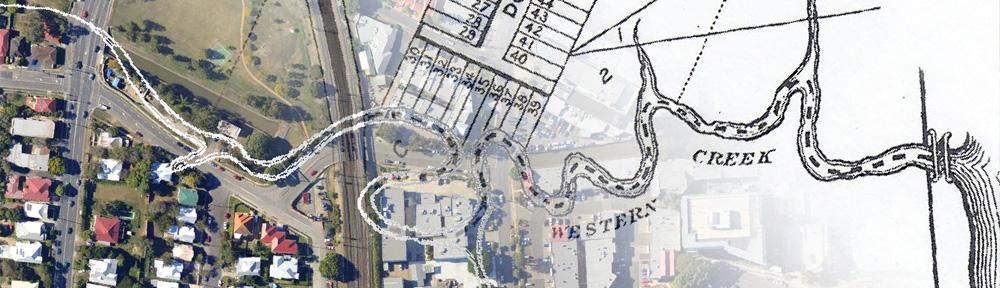
The Western Creek catchment
Following a creek while ignoring its catchment is like studying a tree while ignoring its roots. A creek is really just the final and most visible expression of a process that takes place across a whole landscape. Water falling on the ground follows the path of least resistance to the lowest point. In doing so, water not only follows the lay of the land, but gradually shapes the land itself, carving out channels, gullies and streams as it accumulates along its preferred path. Like the roots of a tree, the tributaries of a stream collect water from across a wider area of land. This area is the stream’s catchment.
Even without knowing the precise historical path of Western Creek, we can determine its catchment area by observing the surrounding topography (hint: look for ridges). This can be done by exploring the area on foot, by studying contour maps, or (as I have done) by using computer software to interpret a digital record of the land’s elevation.

The catchment boundary and streams of Western Creek. The stream paths are approximations only. (Google Maps)
The map above shows the approximate boundary of the catchment. Its accuracy is limited by the fact that it was generated using digital elevation data with a relatively coarse resolution (a 25m grid with +/-10m vertical accuracy). For the present purposes, however, it will suffice. The first thing to notice is that for the most part, the boundary is already on the map—in the form of roads. Evidently, roads are often built on ridges. Birdwood Terrace, Stuartholme Road, Simpsons Road, Macgregor Terrace, Latrobe Terrace and Given Terrace pretty much account for the northern and western parts of the catchment boundary.
Towards the north-eastern corner of the catchment, the boundary departs from Given Terrace near Ranley Terrace, then cuts across the top of Guthrie Street and between Copeland and Moore Streets to the top of Heussler Terrace. It then goes through the Bishopbsbourne (bible college) property, down to the rise in Baroona road, through the Milton shops and up to the top of White Street and Milton Road. By this stage we are getting close to the river, and the steep hills have given way to low, gradual slopes. After crossing the railway line the boundary continues through Douglas Street and Park Road, before meeting the river near Graham Street.
Starting at the south-east corner, the catchment boundary rises along the hill of the Wesley Hospital, crosses Milton Road at the top of the hill between Dixon and Ridley Streets, then cuts between Dart and Jones Streets to meet Birdwood Terrace. The total area of the catchment is about 4km2.
The image below shows a view of the catchment from within Google Earth.
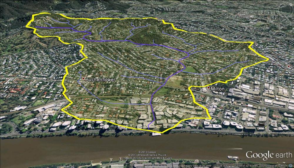
The catchment and streams of of Western Creek.
Subcatchments
By applying the same principles used to identify the catchment boundary, we can also identify subcatchments for the tributary streams. I’ve not yet drawn these onto a map, but again, some are already delineated by prominent roads. Starting at the top of the catchment, Boundary Road road is one example; Given Terrace and the top of Fernberg road are others.
What’s on the other side?
Beyond the catchment boundary lies… other catchments!
Western Creek has three ‘sister’ catchments along what John Oxley called the Crescent Reach of the Brisbane River. These are shown in the image below.
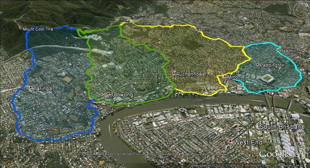
The catchments of the Crescent Reach. From left to right: Toowong Creek, Langsville Creek, Western Creek and Boundary Creek.
Boundary Creek
Between Western Creek and the CBD lies the catchment of Boundary Creek, so named because for a time this creek was the natural western boundary of the city1 (this watercourse was also known as Milton Creek2). Boundary Creek would have started in the slopes of Red Hill up around Cochrane Street, flowing through the Neal Macrossan Playground near Ithaca Pool, through Suncorp Stadium (which was once the burial grounds swamp), and through the office-park area to meet the river near the Go Between Bridge.
Nestled in-between where these two catchments meet the river is a much smaller catchment where there was once a lagoon. An account from 1872 refers to “a fine lagoon running diagonally across the property” bounded by Cribb Street, Milton Road, Park Road and Coronation Drive, mentioning also that “frequently black swans and an odd pelican or two made it a place of call”.3
See This post for more information about the lagoon and the Boundary Creek system.
Langsville Creek
Just upstream of the Western Creek catchment lies the catchment of Langsville Creek, which began in the slopes beneath Stuartholme and had branches flowing through the Mount Coot-tha Gardens, the Toowong Cemetery, Anzac Park and Moorlands Park. Fragments of this creek still exist. I am writing a series of posts about Langsville Creek, starting here.
Toowong Creek
Meeting the river at the very top of the Crescent Reach is Toowong Creek, most of which is still intact today. Toowong Creek starts in the foothills of Mount Coot-tha on the other side of the South-Western Freeway and flows past Toowong High School, Oakman Park and Perrin Park.
Ithaca and Enoggera Creeks
Beyond the top of Birdwood Terrace and the Stuartholme school lies the Ithaca Creek catchment. Ithaca Creek shares the Western Creek catchment boundary all the way round to where Given Terrace meets Enoggera Terrace. The Ithaca Creek catchment is substantially larger than Western Creek and its other neighbours, but it is in fact just a sub-catchment of Enoggera Creek, which as you can see from the image below, dwarfs even Ithaca Creek.
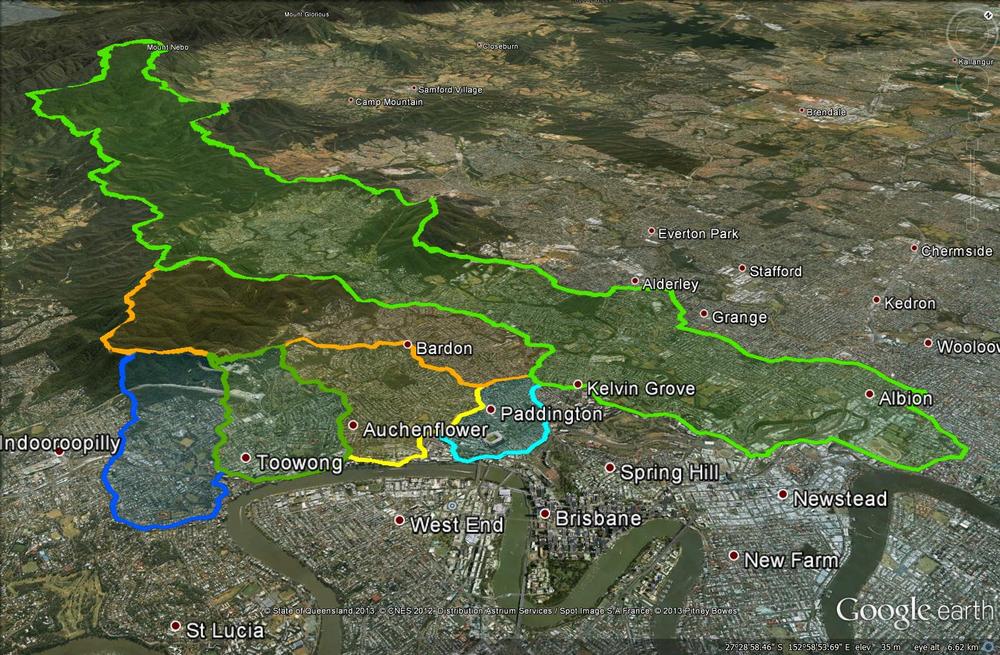
The four catchments of the Crescent Reach along with the larger catchments of Ithaca Creek and Enoggera Creek.
Continue to The course of Western Creek
Notes:
Last modified: May 20, 2013