May Day mayday! A tale of extraordinary weather and extra-ordinary lasagne.

It’s been a long time between posts. As per the forecast, my PhD has reduced this blog from a bubbling stream to a lifeless dry creek bed. But any stream can be revived with a little rain. And with a lot of rain, it all comes flooding back.
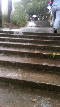
'UQ Falls' - posted to the Facebook group UQ StalkerSpace by Panashé Machinguara just after midday on 1 May 2015.

‘UQ Falls’ – posted to the Facebook group ‘UQ StalkerSpace’ by Panashé Machinguara just after midday on 1 May 2015.

‘A lot of rain’ is one way to describe what Brisbane experienced on Friday the 1st of May, 2015. ‘Extraordinary weather event’ would be another. The gauge in the CBD recorded 182mm of rain in the 24-hour period from 9am that morning. To put that in perspective, the historical average rainfall for the entire month of May is 74mm. The record for the largest daily fall at this time of year stands at 190mm on 26 April 1989, but the recent event set a new daily record for May, with the previous record being 149mm on 9 May 1980.1

Personally, I’d had enough of the rain long before any records were broken. My trip into the University of Queensland at St Lucia that morning took nearly two hours because of a track fault somewhere near Yeronga Station. ‘Local flooding’ was said to be the cause. I enjoyed the rain a lot more from the other side of my office window, but was forced to venture out again at around 4pm. By that time, every road and pathway on the campus was a raging torrent. Continue reading

Notes:

  1. All of this rainfall data is available from the Climate Data Online section of the Bureau of Meteorology website. The historical data comes from the the Brisbane Regional Office station (040214), which operated from 1840 until 1994, while the more recent data comes from the Brisbane station (040913), which commenced operating in 1999.

Topography shock: Postcards from the south

There’s nothing like a change in surroundings to cast your normal environment — that familiar place you call ‘home’ — in a new light. The closer you are to something, the easier it is to forget what makes it special or distinctive.

For me, home has always been Brisbane’s western suburbs. I’ve lived in Bardon, The Gap, Toowong and, most recently, Roaslie (which nowadays is just a part of Paddington). But a few months ago I ventured outside my native habitat, moving across the river to the southside, landing in a sort of semi-rural-industrial outpost called Rocklea.

Like Rosalie, Rocklea is built on a floodplain, and to that extent probably should never have been built at all. But that’s about where the similarities end. It’s not just that you won’t see any cows or two-train semi-trailors in Rosalie, or that the local cuisine there gets more exotic than meat pies.1 For me, the most striking difference between my new environment and my old one is the topography. I’m used to living among hills. In Brisbane’s western suburbs — in Paddington, Bardon, Ashgrove and Toowong, for example — there are ridges that you can follow all the way up to Mount Coot-tha. In those parts of town, you live either on a hill or at the bottom of one.

Not so in Rocklea. If I look to the west from here, the first big hill I can see is the southern tip of the D’Aguilar Range. To the north-west it is Mount Coot-tha and the Taylor Range. The CBD lies nearly 8km to the north, but from here you can generally get city views by climbing a tree.2 To the east it’s easy riding until you hit Toohey Mountain and then Mount Gravatt. To the south, on a clear day you can see just about forever, and leading you most of the way there is the great floodplain of Oxley Creek.
Continue reading

Notes:

  1. Actually I’m being unfair. Although you wouldn’t suspect it, the pie shop at Rocklea does a good Vietnamese pork roll.
  2. If you draw a straight line from the Brisbane Markets to the CBD, you cross the river five times. Unless you cross Highgate Hill, it’s floodplain all the way.