Up hill and down Dale: Where did Elizabeth drown?

In the fourth episode of Uncovering Langsville Creek, I told the story of Elizabeth Dale, who on 31 January 1905 drowned in a waterhole in the Toowong Cemetery. I was intrigued by the notion that there was once a waterhole in this otherwise dry and barren land, so I set about trying to determine its location. I failed dismally, but at least got some mileage out of reporting my misadventure. Thankfully, two readers took pity and provided me with some new leads. I am glad to report that having followed those leads, I can now reveal where Elizabeth drowned. I would only be more glad if no-one else had figured it all out before me.

A wild ghost chase

My first attempt to find the site of the waterhole was as optimistic as it was misguided. The only clue I had was that the waterhole was somewhere near the graves of Elizabeth’s husband and brother. Or at least, that was the inference I drew — incorrectly, it turns out — from statements given at the inquest into Elizabeth’s death saying that her body “was found off a pathway between her husband’s and brother’s graves” and that “the pool was about 20ft. from the pathway”. I assumed that the waterhole and Elizabeth’s husband’s and brother’s graves must have all been close to one another, and that I could deduce the location of the waterhole by finding the graves of a Dale and a Dodd (I didn’t even know their first names) in a low-lying part of the cemetery.

That mission was never likely to succeed. Many of the headstones in the low parts of the cemetery — especially those from the 19th century — were unreadable or missing altogether, and unless I spent all day looking, I was never going to check all of the readable ones anyhow. On the bright side, I had a pleasant afternoon and got some exercise. I felt a little foolish, however, when a reader named Ann Stephens pointed me to a much smarter way of finding graves in Brisbane: the City Council’s Grave Location Search, which enables you to find a grave by specifying the person’s name and the year they were buried. It’s kind of like a Yellow Pages for the deceased. Continue reading

The Western Creek floodgate: a reality after 125 years

Way back in January, I reported that the City Council had begun constructing a floodgate at the mouth of Western Creek. This is the spot where the Milton Drain meets the river, right next to where the dilapidated shell of the old floating restaurant still stands. If you have passed by this spot in the last few months, you will have seen that the construction is complete: Western creek finally has its floodgate.

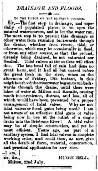
Hugh Bell's letter to the editor of the Brisbane Courier in July 1889, arguing for the use of tidal valves to prevent flooding in Milton and Rosalie.

Hugh Bell’s letter to the editor of the Brisbane Courier in July 1889, arguing for the use of tidal valves to prevent flooding in Milton and Rosalie.

I say ‘finally’ not because more than three and a half years have passed since the 2011 flood (some people might even call that response time quick), but because more than 125 years have passed since a floodgate at the mouth of Western Creek was first proposed. In July 1889, while the mud was still drying from a flood that peaked at 3.75m on the Port Office gauge (about 2 ft lower than the 2011 flood), a Milton resident named Hugh Bell wrote to the Brisbane Courier, asking “Why are not tidal valves or flood gates being used” to prevent flooding in Milton, Rosalie and other low-lying suburbs? This question was no doubt raised again in March of the following year, when the river peaked at 5.33m — just under the mark of the 1974 flood. In response, the Toowong Shire Council in October 1890 unveiled an ambitious whole-of-shire1 drainage scheme which featured floodgates at the end of Western Creek and Langsville Creek. But the council could not afford to build the whole scheme, and so built it piecemeal instead. Some components, such as the drain through Red Jacket Swamp, took years to get finished, while the floodgates never materialised at all.

But the idea didn’t die: it resurfaced after every flood, only to recede again with the memory of the floodwaters. It probably sunk into near-oblivion after the completion in 1985 of Wivenhoe Dam, which — if you believed the real estate industry — was supposed to save Brisbane from ever flooding again. But when the flood in January 2011 proved — unless you believe the real estate industry — that Wivenhoe Dam is not a bottomless pit after all, attention turned once again to more localised methods of flood mitigation. The Brisbane City Council commissioned a study into backflow prevention, and since 2012 has been rolling out the installation of floodgates — more properly known as backflow prevention devices — at prioritised spots along the river. Continue reading

Notes:

  1. The Toowong Shire fronted the river all the way along the Milton Reach, from Boundary Creek (where Boomerang Street is today) to Toowong Creek (near Gailey Road). The boundary between Toowong and Ithaca shires began where the railway line crossed Boundary Creek, and continued along the railway until it reached Baroona Road, then known as the Boundary-road because it divided the two shires all the way up to the top of what is still called Boundary Road today. (Back then, Baroona and Boundary roads were joined at the upper end of Norman Buchan Park.)

Creeks and Catchments seminar, 21 June

Are you interested in creeks and catchments? And history? Of course you are!

Well, if you are free on the afternoon of Saturday 21 June, you might want to come along to a seminar called ‘Creeks and Catchments’ being presented by the Brisbane History Group in conjunction with the Griffith Film School.

I will be presenting about oncewasacreek.org, and there will be five other speakers covering other creeks and catchments in Brisbane, including Moggill Creek, Enoggera/Ithaca Creek, Cubberla-Witton Creeks, and Norman Creek. One highlight is sure to be Trish FitzSimons’ study and short films about the history of Norman Creek, about which I have written previously.

The seminar begins at 12.30pm at the Griffith Film School (intersection of Stanley, Vulture & Dock Streets, South Brisbane). The cost is just $10 for Brisbane History Group members and $15 for non-members. Please see the event flyer for booking details, and be sure to RSVP by 16 June via the details on the flyer.

Hope to see you there.
-Angus

Uncovering Langsville Creek, Part 4 – Something to do with death

This is the fourth in a series of posts about Langsville Creek, which was Western Creek’s upstream neighbour on the Toowong/Milton Reach. Before reading this post, you may like to look at Part 1, Part 2 and Part 3 of the series.

Previously, on Uncovering Langsville Creek . . .

The first three episodes of this little mini-series have unfolded much like a daytime soap: the plot has thickened, but not much has happened. Well, without giving too much away, this is the episode where things happen. It is the murder-mystery end-of-season thriller. Characters will die, secrets will be revealed, and lost worlds discovered. But first, a brief recap.

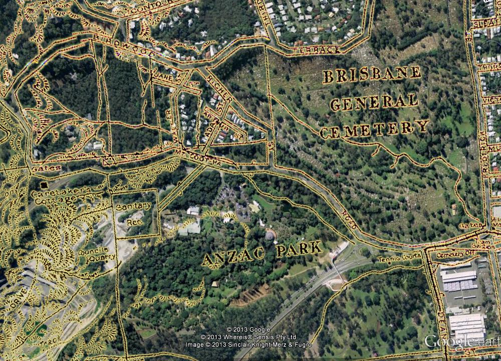
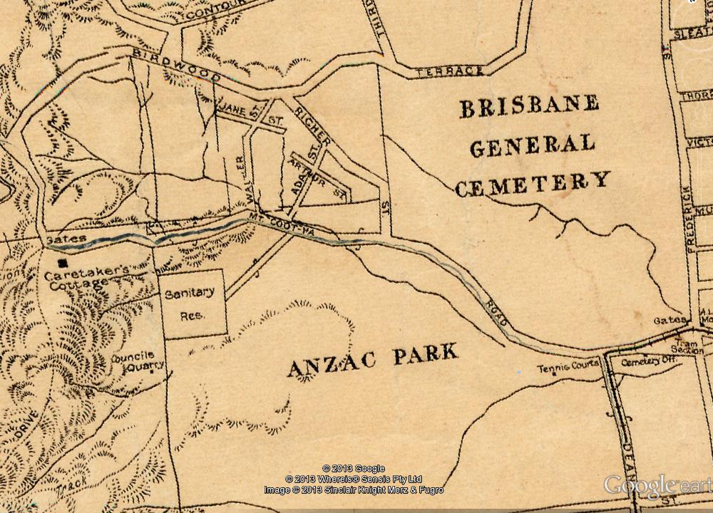
The previous episode introduced the map that you see below, which dates from 1929 and is the only one I have found that shows the upper reaches of Langsville Creek. We explored the stream that runs from the upper-left corner of the map into what is labelled as Anzac Park. Today, the area at the top-left is the Treetops on Birdwood estate, and the area labelled as Anzac Park is the Mount Coot-tha Botanic Gardens (hover your cursor over the image to see the modern landscape). In the slopes below Birdwood Terrace we found the headwaters of Langsville Creek more or less as they have always been — as gullies running through dry scrub. Immediately across the road, however, we found lush rainforest streams flowing into large lagoons, all part of the regulated water cycle of the botanic gardens.

Part of a map of Brisbane dating from 1929 (available online via Brisbane Images). The watercourses shown are the upper reaches of Langsville Creek. (Note that some distortions and artifacts emerged in preparing the map for Google Earth, most notably the giant crack running along Mount Coot-tha Road.)

At the end of the Western Freeway, where the entrance to the Legacy Way tunnel is still being built, the trail ran cold, and the Gardens stream came to an end. It is time, then, to move onto the other two streams — or one of them anyway, as I intend to drag this series out to a fifth installment (check back for it in six months or so). The stream we will look at today flows right through another of Toowong’s famous landmarks: the cemetery. Continue reading

New site map

When I created this site, my vision was of a neat history of the Western Creek catchment. Each part of the catchment would have a page devoted to it, and each page would fit snugly within the structure of the site. But as the site has progressed I have ended up writing about a wider range of topics and locations than I anticipated. The story of Western Creek has become just one chapter within a broader story about the Milton and Toowong reaches of the Brisbane River, which in turn is part of an even broader story about suburban development in Brisbane.

Consequently, much of what I have written does not fit within the site’s page structure, and resides instead within the blog-style posts of the Newsroom. You may have noticed the tag-cloud in the newsroom that attempts to index the assortment of topics and locations discussed on the site, but if you’ve gotten much value out of it, I’ll be surprised. This site’s content is principally about locations, so it really needs a location-based index — otherwise known as a map.

So here it is: the new site map for oncewasacreek.org. You can also access it via the site’s main menu.

Each marker on the map indicates a location that I have written about somewhere on the site. If you click on a marker, you will get a list of the pages and posts that discuss it. This is the most logical and efficient way I have come up with to index the site’s contents, though it does depend on my vigilance in identifying all of the relevant pages for each location. It is entirely possible that I have missed some, in which case you can feel free to suggest some additions.

Also, if you are watching very carefully, you may notice that the Forum is no longer in the site menu. I have decided to retire the Forum, since barely anyone ever used it.