Uncovering Langsville Creek, Part 3 – The Headwaters

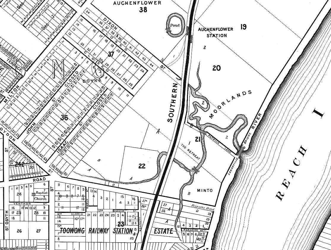
This is the third in a series of posts about Langsville Creek, which was Western Creek’s upstream neighbour on the Toowong/Milton Reach. Before reading this, you may like to look at Part 1 and Part 2 of the series.

I started this series of articles about Langsville Creek as a distraction from my original mission of writing about Western Creek. My new interest soon produced another distraction when I stumbled across a dump of old bottles and cans while exploring Langsville Creek’s headwaters. When I finally finished writing about those bottles and cans a few months later, I took a holiday in Melbourne from which I returned with enough ideas about contrasting topographies to divert myself for several weeks more. Now, having gotten those ideas out of my system, I am resuming work on my first distraction so that some day in the near future I might return to my original goal.

This episode will be pick up the story in the same part of the creek as I got distracted in by those bottles and cans — its headwaters. Having mapped out Langsville Creek’s catchment in the last installment of the series, it is time now to trace where the water flows, and the logical place to start is where the water does: at the top.
Continue reading

Topography shock: Postcards from the south

There’s nothing like a change in surroundings to cast your normal environment — that familiar place you call ‘home’ — in a new light. The closer you are to something, the easier it is to forget what makes it special or distinctive.

For me, home has always been Brisbane’s western suburbs. I’ve lived in Bardon, The Gap, Toowong and, most recently, Roaslie (which nowadays is just a part of Paddington). But a few months ago I ventured outside my native habitat, moving across the river to the southside, landing in a sort of semi-rural-industrial outpost called Rocklea.

Like Rosalie, Rocklea is built on a floodplain, and to that extent probably should never have been built at all. But that’s about where the similarities end. It’s not just that you won’t see any cows or two-train semi-trailors in Rosalie, or that the local cuisine there gets more exotic than meat pies.1 For me, the most striking difference between my new environment and my old one is the topography. I’m used to living among hills. In Brisbane’s western suburbs — in Paddington, Bardon, Ashgrove and Toowong, for example — there are ridges that you can follow all the way up to Mount Coot-tha. In those parts of town, you live either on a hill or at the bottom of one.

Not so in Rocklea. If I look to the west from here, the first big hill I can see is the southern tip of the D’Aguilar Range. To the north-west it is Mount Coot-tha and the Taylor Range. The CBD lies nearly 8km to the north, but from here you can generally get city views by climbing a tree.2 To the east it’s easy riding until you hit Toohey Mountain and then Mount Gravatt. To the south, on a clear day you can see just about forever, and leading you most of the way there is the great floodplain of Oxley Creek.
Continue reading

Notes:

  1. Actually I’m being unfair. Although you wouldn’t suspect it, the pie shop at Rocklea does a good Vietnamese pork roll.
  2. If you draw a straight line from the Brisbane Markets to the CBD, you cross the river five times. Unless you cross Highgate Hill, it’s floodplain all the way.

Bottles and cans: an adventure in suburban archaeology

Suburban secrets

Since I started chasing lost creeks, I have been drawn to spaces that most people would tend to ignore or avoid. For example, I often find myself peering into drains, which in many urbanised areas are the only waterways left. I’m sometimes tempted to venture inside them, but I rarely do.1 Out in the suburbs I’ll look twice at any gully or ditch that has not been covered over. These watercourses sometimes run through scenic parks, but more often they are tucked away in roadside scrub or remnant bush.

The bushland between Mount Coot-tha Road and Birdwood Terrace, where I stumbled upon a gully full of bottles, cans and other rubbish. View Larger Map

Exploring suburban gullies is hardly a taboo like venturing into drains, but neither is it a popular pursuit. For all of the prickles and scratches you are likely to endure, you can hardly expect to see nature at its finest.

Yet to me, there’s a certain appeal about being in a space that in all likelihood has not been looked at for many days, walked through for many weeks, or cleaned up for several years or decades. Such places remind you that there are still things to discover in an otherwise predictable suburban environment. If you keep your eyes peeled in a place like this, you never know what you might find.

I recently found myself in just such a place while exploring the headwaters of Langsville Creek. This creek exists only in fragments now, but it once flowed all the way from the Mount Coot-tha Quarry to the Brisbane River at Auchenflower. Its catchment neighbours that of Western Creek, the forgotten waterway that is the main focus of this website.

My exploration of Langsville Creek had taken me to a patch of bushland between Mount Coot-tha Road and Birdwood Terrace. I followed the Old Mount Coot-tha Road from near the entrance to the botanical gardens, and walked downhill through a clearing not far from Walter Street. Before I knew it, I was at the bottom of a damp and weedy gully.

Continue reading

Notes:

  1. Kids used to explore drains all the time, but these days it is something of a taboo — and for good reasons. Thankfully, there are still a few underground explorers around to remind us what remarkable spaces drains are. (For more examples of drain photography, see subduedmidnight.com and longexposure.net.)

Uncovering Langsville Creek, Part 2 – The catchment

This is the second in a series of posts about Langsville Creek, which was Western Creek’s upstream neighbour on the Toowong/Milton Reach. You may want to check out Part 1 and Part 3 of the series.

The whole iceberg

Langsville Creek as depicted on A.R. McKellar's map of Brisbane, published in 1895.

Langsville Creek as depicted on A.R. McKellar’s map of Brisbane, published in 1895.

If you look at the Milton Reach of the river on any of the old maps of Brisbane, such as the one drawn by A.R. McKellar in 1895 (shown to the right), you will notice a creek with several winding branches that meets the river at Patrick’s Lane. This was known as Langsville Creek. As we saw in Part 1 of Uncovering Langsville Creek, the creek as it was depicted on the old maps is now gone. A few drain openings are about the only physical reminders left of what must have once been a prominent part of the landscape.

But there must have been more to Langsville Creek than just the meandering branches shown on the early maps. Each of these branches must have had an origin somewhere further upstream. With one or two exceptions, the early maps show nothing of those upstream parts of the creek. Our understanding of Langsville Creek will remain very superficial, however, if we do not look further than what we can see on the maps. It would be like trying to understand an iceberg while ignoring everything under the water. If we want to uncover Langsville Creek and its legacy in today’s landscape, we need to look further upstream: we need to see the whole iceberg.

Continue reading

Uncovering Langsville Creek — Part 1

This is the first in a series of posts about Langsville Creek, which was Western Creek’s upstream neighbour on the Toowong/Milton Reach. I do not intend to research Langsville Creek fully at this stage, as I have too much still to learn about Western Creek. But I couldn’t resist tracing the path of this (mostly) lost creek and seeing what can be learned by looking at the some of the old maps and aerial photographs. Each post will look at a different part of Langsville Creek. This one focuses on the lowest reaches of the creek, near where it met the Brisbane River. You can also now read Part 2 and Part 3 of the series.

The meanders of Moorlands

Toowong Cemetery … Anzac Park … the Mount Coot-tha Botanical Gardens … Quinn Park … the McIlwraith Croquet Club … Toowong Memorial Park … Moorlands Park.

What do all of these places have in common? The answer is a creek. Not a creek you are likely to have seen or heard of, for there are few traces of it left today. But there once was a creek that flowed through all of these locations.

The creek uniting these locations was known to early Brisbanites as Langsville Creek, though I imagine that it also had names given to it by the Turrbal people long before Europeans arrived. I’ve not read up on how and when it came to be known as Langsville Creek, but given that just about everything else in this part of Brisbane is named after John Dunmore Lang, I’m going to take a punt and guess that this creek was as well.

Langsville Bridge at Auchenflower, ca.1910. (State Library of Queensland, Negative no. 118279)

Langsville Bridge at Auchenflower, ca.1910. (State Library of Queensland, Negative no. 118279)

You can see Langsville Creek — or at least part of it — on the early maps of Brisbane. It’s depicted most clearly on McKellar’s 1895 map, the relevant portion of which is reproduced below. The creek itself is unnamed on this map, except by way of the bridge that crosses it where Patrick Lane meets the River Road (now Coronation Drive). The creek looks rather like an outgrowth of the river, as if the river has put out tentacles or feelers, each one meandering through the landscape much as the river winds its way to the bay. The land surrounding it appears to be mostly undeveloped, presumably because it was damp and flood-prone.

Continue reading