

You member?
As time marches on, more and more old photos depict scenes for which there is no longer any lived memory. For the most part, this is a sentimental concern rather than a practical one. But if the last lived memory fades before the facts surrounding a photo have been recorded, we can find ourselves in a pickle.
Whereas our cameras and phones today add geocoordinates to the metadata of every photo we take (whether you know it or not!), the photographers and archivists of the past were not always so helpful. Vague descriptors like “Floodwaters in Milton” or “View over Paddington” are often the only geolocators handed down with our treasured historic vistas, and that’s if we’re lucky. Sometimes we can’t even be sure that the descriptions are correct. Maybe the actual photographer wrote a note on the back of the print, or maybe it was a descendent or an archivist several steps removed, giving it their best guess.
This is where social media and the wisdom of the crowd can shine. Post such an image in your local history group on Facebook, and someone with just the right perspective might identify a building or distant landmark that definitively places the image. Or, just as likely, a few competing theories will be offered, some fond memories of the supposed place will be traded, and we’ll move on to the next yummy helping of member berries.

Anyway, this post is about one such photo — a photo old enough that member berries can’t help us, at least not without some member mushrooms taken on the side. It shows a world that few of us alive today would have laid eyes on: crowds of people swimming in a pool that has been dug into bare earth. Men and boys mingle in the pool, while women in their Sunday best watch on. In the background, a cricket match is being played against gently sloping, almost totally bare hills. Or are those farm houses in the hazy distance?
Membering Ithaca Pool
If you’re a member of any of Brisbane’s history groups (real or online), or have ever delved into the history of swimming in Australia, there’s a very good chance you’re familiar with the image I’m talking about:

You can find in the State Library of Queensland’s catalogue with the description ‘Crowd at Ithaca Creek swimming hole, ca. 1910’. I first came across it years ago and immediately assumed that it showed an embryonic version of the modern Ithaca pool at the bottom of Caxton Street in Paddington:

It makes intuitive sense to link this historic photo to the Ithaca Pool. The site is in a low-lying, previously swampy part of the Boundary Creek catchment, on land that was part of a disused cemetery reserve — a perfect place to dig a waterhole if you ignore the part about the buried dead bodies. And what better place to construct more permanent, modern baths than where people already go to swim? There’s even a Cricket Street just nearby, which could explain the cricket match! As for the reference to Ithaca Creek in the title, well, given that Ithaca Shire took its name after the creek, it’s natural that the names would have sometimes been used interchangeably.
At the time of writing,1 you will find this interpretation of the photo in the top search result, and in the AI overview, if you google something like ‘Ithaca swimming pool history’:

The page behind this result is an article about the pool’s history by a local writer2 named Terie-Lea Tobin, titled Hidden gem in Paddington. The title makes more sense when you realise that it appears on the website of a real estate agent.
Tobin explains:
The Paddington Cemetery Act was passed in 1911 by Queensland Parliament, which authorised the government to resume the burial grounds and relocate the remains to another site.
Around this time the locals took advantage of a cleared space on the northern side of the cemetery and fashioned a pool of sorts. It was little more than a rudimentary pit filled with water pumped from the Brisbane River.
This account fits the content of the image as well as its supposed creation date of around 1910. But is there any evidence so support it? To Tobin’s credit, she provides links to several Trove articles about the Ithaca Pool, but none of them substantiate this particular claim. They all date from after the modern baths were opened in 1916, and none mention any previous baths at the site.
Google returns no other solid attempts to place this image, but it does find some discussions on Facebook, including this post from 2022 in Old Brisbane Album.3 If you drill down into the comments, you’ll find a lively debate4 about whether the image shows the site at Caxton Street or instead a waterhole on Ithaca Creek near School Street, now named Lugg Street, on which Ithaca State School is located.
In the Ithaca Creek corner, one group member cites a reproduction of the image in the Ithaca State School Centenary Yearbook 1985. In the Caxton Street corner, another member cites the article discussed above by Terie-Lea Tobin and a reel of images posted in the same group in 2020, the description of which says (without citing any evidence) that the Ithaca Pool
started out as a free-form swimming hole dug out of the ground on the former site of the Paddington Cemetery. There’s a cricket match behind where Suncorp Stadium stands today.
Oh, it is so on! One image, two competing theories. Which story will prevail? Whose account of the scene will reign supreme?

Ithaca Creek would like a word
I did my best earlier in the post to gloss over the fact that the SLQ catalogue describes the image as the ‘Ithaca Creek swimming hole’ rather than placing it in ‘Ithaca’ or ‘Paddington’. But in light of the evidence about the school centenary booklet, we clearly need to take more seriously the idea that the picture shows a water hole near the actual Ithaca Creek.
The the full SLQ catalogue record for the photo certainly takes this theory seriously. The longer description says:
Crowds at Ithaca Creek swimming hole which was situated at the bottom of School Street, Ithaca. Bathers swim in the water and stand around the edge of the swimming hole. Spectators line the earth bank of the swimming hole in front of the wooden shelter. A rail fence surrounds the swimming hole area. Some people play cricket in the backgorund.
And there is this ‘User comment’ form a ‘KB’ in August 2022:
I have had to do some research on the image and found a copy of it in Ithaca Creek State School centenary booklet 1885-1985 (record no. 21106011480002061) which refers to it as the Ithaca Creek Swimming hole.
This comment might explain why I had no memory of the catalogue mentioning Ithaca Creek the first time I found this photo. I suspect that the record then looked much like it does on the state library’s Flickr page, last updated in 2016, where the image is titled Crowd at the swimming pool ca. 1910, and is described as “Crowd at the swimming pool, possibly in the Ithaca area.” In any case, I’d love to know if the librarian’s research on the photo turned up anything other than the centenary booklet. Perhaps I’ll track down KB another day.
As for the booklet itself, the good news is that we don’t need to go to the library to see it, because a helpful Facebook user has taken the trouble to post all 51 pages of it on in the Ithaca Creek State School Facebook group. Here is the relevant page:

These are some very inconvenient facts for Team Caxton Street. Why did someone who contributed to the school centenary booklet back in 1985 possess a copy of the photo (remember that you couldn’t just download it from the SLQ website back then!), and why did they believe it showed a pool at the bottom of Lugg Street? This is a very specific claim to have made up, especially 75 years after the fact.
On the following page of the booklet, there’s an anecdote that is sufficiently detailed to convince me that there was swimming hole somewhere on Ithaca Creek:
In earlier times they had to be content with swimming in Ithaca Creek where the water was held back by a concrete retaining wall. The spot was very popular with the local residents who would meet there socially on weekends and other occasions.
Even so, I wanted some firmer evidence for the Ithaca Creek swimming hole. So I did what any good armchair historian does, and plunged into the newspaper records in Trove.
The question of baths in the shire
After trawling through dozens (scores? hundreds?) of newspaper articles from the early 1900s and beyond, I can confirm that there was most definitely a swimming hole on Ithaca Creek in the place where the centenary booklet claims. I’ll get to the evidence shortly, but let’s start by digging into some of the early discussions surrounding public baths in Ithaca Shire.
As is often the case with public works, the idea of public baths in the Ithaca Shire5 preceded the reality by many years. One of the earliest instances appears in the candidature speech of a Mr William Valentine for the No. 1 Subdivision6 of the Ithaca Shire Council in January 1890. As the Evening Observer reported:
Regarding Ithaca as a little town in itself, he thought that it should have a school of arts and reading room, or a branch of the Brisbane School of Arts; that it should have water laid on; that it should be lit by gas; and that it should be provided with a tramway. (Cheers.) [ . . . ] He approved of financial separation of the wards to a certain extent; he would like to see swimming baths established; and he was quite prepared to stand or fall on his personal merits. (Hear, hear.)
Valentine’s speech was well received, and he was ultimately elected,7 but the council must not have seen the baths as a priority alongside the more urgent matters such as water, lighting and transport.
The council considered a motion for baths on Given Terrace in 1897, but did not seriously discuss baths again until 1900, when the Queensland Amateur Swimming Association began lobbying for a pool in the district. The Western Suburbs Athletics Club made similar urgings, and proposed the recreation reserve at Caxton Street as a suitable location. At the council’s request, the state government reclassified this land from a reserve for recreation to one for swimming in October 1901, but the council did not have sufficient funds at the time to build swimming baths, and at least some of their constituents agreed that there were more pressing priorities.
Still, the push for baths continued. Councillor Arthur Hawthorn presented a petition “praying for the erection of swimming baths” in March 1902, and a committee that was formed to consider the matter reported in July, suggesting “the erection of the actual bath body only, leaving the elaboration of the plan to some future time.” They estimated the total cost at £950, or about $120,000 in modern terms.8 Even this restrained proposal must have been beyond the council’s means, because nothing materialised in the several years that followed.
Arthur Exley’s budget baths
Perhaps the councillors were dreaming too big. In December 1901, the council received a letter from Arthur Exley, the head teacher of the Ithaca Creek State School, outlining a more modest proposal. He suggested
that a large, clean waterhole at the bottom of the school hill might be deepened and a dressing-shed put up, and it would make a good bathing-place where the children could be taught swimming. The members expressed themselves in sympathy, and the matter was left to the Works Committee.
Exley’s budget proposal sat on the backburner until 1907, when Ithaca’s mayor, George Sweetman, was urged to revisit the idea. In the council meeting on 9 December 1907,
The Mayor reported that an excellent site for the erection of a public bath had been found in Ithaca Creek, in the vicinity of Mr Trouton’s residence. The property belonged to the Queensland Trustees, who had expressed their approval of the scheme, which, he thought, would not cost more than about £30 or £40. The establishment of a bath in the place mentioned would be a boon to the school children and to the district in general.9
The Mr Trouton referred to was William Trouton, a well-known chemist whose Beth-Eden estate stretched from Woolcock Park at Waterworks Road to the present-day St Finnbar’s church, the site of which contained his residence.10 The Queensland Trustees was not the public trustee as we know it today, but a privately owned, government-regulated investment company that performed a similar role with respect to handling deceased estates.11
In the same meeting, Mayor Sweetman explained that baths “40ft. by 27ft. with a depth of 4ft could be erected to provide bathing facilities for from 500 to 600 persons.” Presumably he did not mean all at once, given that this converts to just two square feet per person!
For once, things must have moved quickly, because the baths officially opened just six weeks later on Saturday 18 January 1908:

If there was any doubt remaining about where the baths were located, I think this ad clears it up. They were on the creek, at School Street (now Lugg Street), off Arthur Terrace — exactly where the school’s centenary booklet and the State Library’s catalogue locate it.12
Arthur Exley wrote to the council to express his thanks on behalf of the school, but not everyone was happy. In the council meeting on 3 February,
several aldermen pointed out nuisances or anomalies, which existed at present, even mixed bathing, it was said, being allowed, much to the dislike of the gentler sex.
These nuisances and anomalies became irrelevant just ten days later when the baths were wrecked by floodwaters.13
The Mayor stated that the wall had not been built in the right place, and the recent fresh in the creek had carried away the foundation, with the result that there were large cracks in the wall. Another fresh would carry it away altogether. He urged immediate action, and advised the aldermen to allow the baths to remain at the creek. He also suggested the passing of a bylaw, providing for the proper control of the baths.14
In relation to the last point, the Ithaca School Committee asked for control of the pool in the hope that they could salvage it for the remainder of the season. This apparently did not happen, as the School Committee went as far as offering £40 in November 1908 “towards the reconstructing of a swimming baths on Ithaca Creek, provided that bylaws for the regulation of the baths were framed, and a measure of control was given to the committee.”
The late baths of Ithaca Creek
Having been open for barely a month before being put out of commission by floodwaters, the Ithaca Creek baths were never revived. But they were missed. In the council meeting on 15 August 1910,
Ald. Hawthorn, pursuant to notice, moved that the council take steps to consider the advisability and ways and means of erecting a swimming bath in the town. He felt sure that there was no doubt as to the benefits accruing from the baths which were washed away in Ithaca Creek. Mr, Exley, headmaster of the State school there, had declared that the children never came to school in so cleanly a condition as during the time the baths existed. (Laughter.)
While the motion was carried unanimously, Alderman Robert Speedy expressed concerns about sanitation in any future baths, noting that “the residents in the immediate vicinity of the late baths regarded the structure as a menace to the health of the neighbourhood.”
The bumpy road to the Ithaca Pool
And so began another protracted process of agitations for new baths, deliberations about where they should be located and lamentations about the lack of money to build them.15 Consideration was given to the Oval Reserve (now McCaskie Park) in Kelvin Grove, a site on Given Terrace16 and Lang Park.
As late as March 1916, in response to an enquiry from the Department of Public Instruction, a councillor “expressed regret that a motion in establishing a baths was rescinded, for what reason he did not know.” In a particularly fiery meeting in May 1916, the council voted down a motion asking the finance committee to report on the costs of erecting and operating baths at Caxton Street, but not before one councillor had “expressed his distrust of the Government’s promises in connection with the baths.”17
I could find no further discussion of the baths until the council meeting of 12 September 1916, when it was reported that Dick Cavill, a famous Australian Swimmer, had offered to lease the swimming baths at Caxton Street for 12 months at £1 per month for up to three years. The councillors rejoiced at the prospect of making a profit from the baths after all, and a deal was struck to lease the baths at £50 per year, the capital cost having come to £800, or about $100,000. The baths were opened amid great fanfare on 21 October 1916.
The imagined swimming hole at Caxton Street
In all of the reports of the Ithaca Shire Council’s discussions about public baths from the 1890s until the opening of the Ithaca Pool in 1916, there is not a single reference to an existing swimming hole or facility at Caxton Street, or for that matter anywhere else in the shire except at Ithaca Creek. Nor was anything of relevance reported prior to the council being established in 1889.
I think it’s safe to say that a swimming hole at Caxton Street never existed. If it had, I don’t see how it could have so completely escaped the attention of the council. How could such a facility not have featured in the council’s many discussions about the need for public baths in the shire? How could the council have avoided ever discussing the costs and practicalities of building, maintaining and decommissioning a hole this big? Where were all the complaints about public health and safety that would have inevitably arisen from such a large, untreated body of water?
Even if we ignore this lack of evidence, I believe that a close examination of the photograph itself is enough to rule out Caxton Street as the location of the scene. First, we need to decide which way the photographer was looking. One possibility, implicit in the Facebook post that describes “a cricket match behind where Suncorp Stadium stands today”, is that we are looking towards Caxton Street from the northern side of the pool. This would allow for plenty of flat ground on which to play cricket, but would also require us to edit out Caxton Street itself, as well the other built structures that would existed on those hills at the turn of the century.
I haven’t found a picture of the area from that specific time, but there are earlier photos that can help us. For example, take this one from the 1870s:
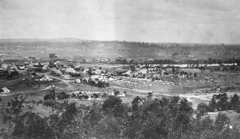
I am yet to chase down the source of this image, but it is reproduced (and apparently misattributed) in a publicly available paper about the cemetery.18 I have spent enough time studying this image and walking on the ground with the image in my hand to be satisfied that the road running across the middle from right to left is Caxton Street,19 which means the purported swimming hole would need to be somewhere between the small bridge and the closest plot of the cemetery, as marked in the zoomed in section below.

If Caxton Street was this well defined in the 1870s (albeit not raised as much as it is today), complete with a bridge over what was left of Boundary Creek, it would have to be visible in a photo looking towards Lang Park 30 years later, as would all kinds of other things (fences, telegraph poles, sheds) besides grass, bushes and a few houses perched on top of hills.
Or perhaps we are looking towards Lang Park, but from the southern side of Caxton Street, across the road from where Ithaca Pool is today. This negates Caxton Street, but I still don’t think it permits the view in the photo.
And just in case your solution involves any glimpse of the slopes leading up to Petrie Terrace, or even up to Bishopsbourne above the brewery, you might want to keep this picture in mind:

Like the photo above, this was taken about 30 years before the picture of the swimming hole (unless the date on that is wrong, which is entirely possible), but it shows how hard it would be to find a view from near Caxton Street that had so few built structures in it.
If you could find a view without houses, chances are you would be looking straight into the cemetery. Most sources I can find suggest that the process of removing gravestones was not complete until at least 1913. This leaves a very small window of time between when the photo could have been taken and when the Ithaca Pool opened in 1916.
Finally, look at the hills in the background of the picture of the swimming hole. They look fairly high, right? There would be no hills like this in view if we were looking towards the river, and the hills in any other direction would have more houses on them.
Ok, so we can’t be looking towards Lang Park. What if the photographer was perched on Caxton Street looking down towards the swimming hole and through what is now the skate park or the Neal Macrossan Playground? Again, the hills are a problem. The land in reality slopes down towards the west from Ithaca Pool, not upwards, so what is that hill on the left of the image? Perhaps the other hills could be those leading up to Musgrave Road and Petrie Terrace, but if so, why is there no sign of Hale Street, or of any of the other roads and allotments that were already marked on McKellar’s map from 1895? There are plenty of references in Trove to houses and street improvements on Caroline, Beatrice and Helena streets prior to 1910,20 and the slopes of Petrie Terrace would have been densely populated by then.

The mountains behind the hills
There’s one other detail worth noting in the background of the photo, though you could be forgiven for missing it. On the horizon above the top of the hills are houses, trees, and, if I’m not mistaken, the outline of a mountain range. These features only become clear when you load the image into an editor (even the app on your phone should do) and adjust the levels, as I have done in the cropped sections below:


Tell me those aren’t mountains beyond the houses on the ridge in the second image. Or are they just some other, really big hills? If they are mountains, they could plausibly be Mount Coot-tha and the Taylor Ranges. From Caxton Street, these mountains lie to the west, but I doubt they’d be visible behind the much closer hills around Latrobe Terrace.21 If the photographer was looking in any other direction, there simply wouldn’t be any distant mountains to see — at least, none that loomed this large and high on the horizon — even without Red Hill standing in the way.
Enough! Unless someone digs up some new evidence to change my mind, I’m satisfied that there never was a swimming hole — or at least none like the one on the photo — near Caxton Street before the Ithaca Pool was built in 1916, and even if there was, this photo almost certainly does not depict this location in or around 1910.
The remains of the late baths of Ithaca Creek
So if there was a water hole on Ithaca Creek near Lugg Street, and there almost certainly wasn’t one in Caxton Street, does this mean that the photo shows the swimming hole at Ithaca Creek?
Maybe. But I have my doubts.
Mostly, I can’t bend my head around the depicted waterhole being part of Ithaca Creek, especially in its confirmed location below Lugg Street. To start with, it looks as though the creek in the old photo has been completely dammed, which I doubt would have been legally permissible or socially acceptable. I think the market gardeners and other downstream users of the creek would have had some words to say about that! Although the descriptions of the swimming hole refer to a retaining wall, my assumption was that the wall was not so high as to prevent water flowing completely. But this is just a guess: I’d love to hear from someone who knows how these sorts of things were done back then.
A site visit did little to convince me. Standing on the footbridge and looking over this part of the creek a few weeks ago, I had a hard time imagining the scene from the photo before me. But perhaps I wasn’t imagining hard enough, in which case I’ll try again next time I’m in town. (Or if you live nearby, please do some imagining for me and report back!)

On the other hand, I had no trouble imagining that the stream below the bridge had once been widened, deepened and straightened to facilitate swimming.

I didn’t take any measurements, but this straight section can’t be too far off Mayor Sweetman’s proposed measurements of 40ft (12m) long, even if it seems a little shy of his proposed 27ft (8m) wide (which, to be fair, is in the ballpark for the hole in the old photo). I couldn’t see any evidence of the old retaining wall when I passed through, but nor did I get a chance to look closely.
If the shape of the stream here really is an echo of the original swimming pool, then I think this is really neat, and something that should be more widely known.
The state of the estates
But the question remains: is this the swimming hole in the old photo? Even if we suppose that this part of the creek could have been dammed and terraformed to look like the pool in the photo, we still need to consider the shape and state of the surrounding landscape.
As with the area around Caxton Street, I suspect there would have been more built structures on these hills in 1908 than we can see in the photo. Keep in mind that if the wall of the pool is the downstream end, we must be standing on the northern side of the creek looking south towards the school. Where then is School Street, or Arthur Terrace, or any evidence of the subdivisions that had been sold in that area as early as the 1880s?
The Dillons Hill Estate, for example, set out nearly 50 allotments along Arthur Terrace, Grace Street, Dacca Street and Lugg Street (the latter labelled simply as a Government road). Even if these allotments weren’t developed right away, could there really be not a single fence, house or fruit tree in view 20 years later?

Indeed, McKellar’s map from 1895 even shows the allotments along Jason Street (the unnamed street under the 822), although these would have been out of view to the left of the photo.

There is plenty of evidence in Trove to show that people were living in this area in 1908, including on Arthur Terrace and Dacca Street,22 which would have been about 100 metres up the hill from the pool. A dive into the post office directories of the day would yield a more detailed picture, but I’m not sure that we need one. The point is that to place this photograph on Ithaca Creek looking up towards the school, we need to find a viewpoint that would entirely evade the houses in the Dillon’s Hill and surrounding estates.
Then again, this problem goes away if the distance to the houses on top of the hills is less than I am imagining. Perhaps we can only see about 100m up the hill, and those are the houses on Arthur Terrace. There must be a systematic way to estimate distances in a photo like this, but I haven’t found time to figure it out. If anyone has some experience in this area, I’d love to hear your thoughts.
If, somehow, it made sense for the pool to have a wall on the upstream end, then we could be looking from the southern side up towards Waterworks Road. The state of the land here would probably check out, as it was apparently subdivided later than the land on the southern side of the creek (see McKellar’s map, above).
But apart from begging the question of how water got into the pool, this perspective cannot explain the mountains above the hills, which, as shown earlier, become visible when the levels of the image are adjusted. If these mountains are the Taylor Range, then their position in the photo would at least be consistent with the view from the northern side of the creek — at least insofar as I can tell by playing around in Google Earth.
Coming up for air
I still don’t think I’ve gotten to the bottom of this pool, and yet I feel like I’m drowning in all the information, theories and possibilities I’ve uncovered. There are always more depths to be probed, but for now, let’s come up for air, take a deep breath, and take stock of what we have learned.
Firstly, there was, without doubt, a swimming hole in Ithaca Creek near the bottom of what is now Lugg Street. It opened on 18 January 1908, was destroyed by floodwaters four weeks later, and was never officially used again. To this day, there is a straighter, wider section of the creek in this location, which could well be a physical legacy of the pool.
Secondly, there was almost certainly never a swimming hole in the reserve on Caxton Street until the Ithaca Pool was established in 1916. If there was, there would have been some trace of it in the Ithaca Shire Council’s many discussions about swimming baths in the shire. Even if there was a swimming hole at Caxton Street, the undeveloped state of the surrounding land (and the lack of gravestones!) in the photo makes it very unlikely that the photo shows this location.
And thirdly, there are reasons to doubt that the photo depicts the swimming hole on Ithaca Creek. Aside from the work (and permission) required to dam and modify that part of the creek to make it look like the photo, there is no sign of the roads and other structures that must have existed on the surrounding landscape at the time.
So where the bloody hell is it?
But if the photo doesn’t show the pool on Ithaca Creek, and there was no such pool in Paddington, what the hell does it show?

This question feels so hard to answer that I’d rather believe that the photo shows Ithaca Creek after all. If the photo showed a swimming hole someplace else, I wouldn’t even know where to start in surveying the possibilities. Perhaps someone else is up for the challenge.
And in spite of the doubts I’ve articulated above, I can’t shake the fact that the photo found its way into the school’s centenary booklet in 1985. When that booklet was produced, there may well have been people involved with lived memories of the pool. And those memories aside, why did the school, or at least someone who worked on the booklet, have a copy of the photo in the first place, if not because they had some traceable connection to the person who took or commissioned it? Unfortunately, the state library’s catalogue reveals nothing about the lineage of the photo. Did the library get it from the school, or did the school get it from the library?
There’s one other question about the photo that nags me. While obsessing over where it might have been taken, have we given enough consideration to when? Is there anything about the scene that can confirm or disprove that it was taken in 1908? The clothes, perhaps, or the optical quality of the image? I’ve seen a lot of photos from around this time that look much clearer than this, but of course it’s entirely possible that the photographer was using older equipment. And given that I am clueless even about today’s fashion, let alone that of 120 years ago, I am not going to weigh in on what the people in the photo are wearing. But surely someone else out there could confirm whether the clothes in the picture are consistent with 1908 — because if they aren’t, the waterhole cannot be the one on Ithaca Creek.
Regardless of where or when this wonderful photo came from, it has proven to be a rich source of intrigue, contention and confusion over the years. I suspect it will continue to be so in the years to come.
- With any luck, the current article will change things soon!
- Or more precisely, a copy writer, assuming that this is her LinkedIn page.
- Interestingly, this post cites the Brisbane City Archives as the source of the image, but the provided call number doesn’t yield any hits in their catalogue now, and I can’t find the image using keywords either. This is not to say that the call number is wrong. I’ve found that many BCA call numbers that I recorded in the past no longer return any results, which begs the question of what value the call numbers were to begin with.
- It actually turns a little ugly at one point. It suffices to say that some people have strong feelings about what this photo may or may not depict!
- The Ithaca Shire extended from Milton, Rosalie and Rainworth in the south to Ashgrove, Red Hill and Kelvin Grove in the north, where it was bounded by Enoggera Creek. The original declaration of the boundaries, including the subdivisions, can be found in the Moreton Mail, 2 August 1889, p5. Also see this map of all pre-1925 shire boundaries in Brisbane.
- This was the north-eastern part of the shire, encompassing parts of Kelvin Grove, Red Hill and Ashgrove.
- You will see his name appearing in subsequent reports of council meetings, such as this one.
- For all historical currency conversions in this post, I have used the RBA’s pre-decimal inflation calculator. I make no guarantee about the accuracy.
- £40 would be approximately $5,000 in today’s terms.
- There are some references to Beth-Eden in Trove, including sales of the property in 1917 and 1923.
- I can’t find a single source explaining all this, but the Queensland Trustees Limited started out in 1888 as the Queensland Permanent Trustee Executor and Finance Agency Company. The name changed to Queensland Trustees Limited with an act of parliament that passed in October 1892. You can get a taste for the scale and scope of their activities through the reports of their annual meetings, such as this one in 1905. Not that there is any doubt about the approximate location of the waterhole, but it would be an interesting exercise to identify the exact portions along the creek that were held by the Queensland Trustees in 1908.
- It’s worth noting that the original School Street extended all the way down to the creek — or at least it did on McKellar’s 1895 map of Brisbane, reproduced later on in this post.
- Rainfall records available from the Climate Data Online section of BoM’s website shows that 157mm fell over Milton between the 10th and 14th February 1908, with 50mm falling on both the 12th and 13th.
- In another account of the same meeting, Sweetman reported that “the lower retaining wall had been carried away by the flood”.
- The lack of money or value, for money, is also mentioned in July 1914.
- The land was known as ‘the reserve’, and was being offered for lease by a Mr W. J. Graham. Google thinks this might be Paddington Central, but doesn’t provide any proof!
- The Department of Public Instruction had apparently “promised £10 for every 100 scholars who should use the baths”, but only up to a limit of £80, or about $10,000.
- Kevin Rains and Jonathan Pragnell (2002), ‘Background to the University of Queensland Archaeological Services Unit’s Lang Park Salvage Excavations: History, Significance Assessment and Methods’, Queensland Archaeological Research, vol 13, pp 21-30. Accessed online, 9 September 2026.
- We are looking from somewhere on Musgrave Road, with the hill of Upper Cairns Terrace visible in the lower right. As Caxton Street goes up the hill to the left of frame, it intersects with Hale Street and ultimately ends up at the old Gaol (now the Barracks), visible at the far left.
- For example, Caroline Street in 1894 and 1908; Beatrice Street in 1907; and Helena Street in 1901
- I’m happy to be corrected by someone who has the luxury of standing on the ground near the bottom of Caxton Street and looking towards Mount Coot-tha. From Melbourne, I can only tell so much with Google Earth and Streetview!
- For example, Arthur Terrace in 1897; and Dacca Street in 1893 and 1906.
Leave a Reply